- Caught on camera | Tornado touches down in Missouri
- Carolina Hurricanes playoff tickets go on sale next week
- Weather Impact Alert: Cold front could trigger severe weather in Houston area this weekend | See timeline
- Violent storms cut through the South and Midwest, spawning tornadoes and killing 3
- Above-normal active 2025 hurricane season predicted by Colorado State University
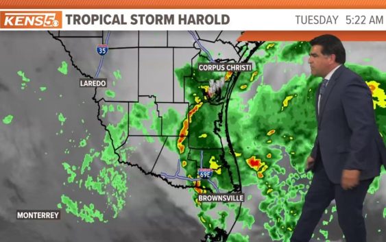
Tropical Storm Harold makes landfall on the Texas Gulf Coast, bringing rain and cooler temperatures

San Antonio is set to receive some rain thanks to the tropical storm, as well as lower afternoon highs.
TEXAS, USA — Texas —
7 a.m. UPDATE:
Newly formed Tropical Storm Harold located over the western Gulf of Mexico is anticipated to continue its westward motion and impact South Texas Tuesday with heavy rain and gusty winds. Rainfall amounts of 3 to 5 inches, with isolated higher amounts up to 7 inches, through early Wednesday could produce scattered areas of flash flooding. A Slight Risk (level 2/4) of Excessive Rainfall has been issued for the region. Additionally, tropical storm force winds will accompany the system as it progresses inland, as well as rough surf along the coast. By Wednesday and Thursday, Harold and its remnant moisture is forecast to push into northern Mexico and the Southwest/Southern Rockies. This may lead to additional flash flooding concerns, especially near the more flood-prone slot canyons in Utah on Thursday.
———————–
9 P.M. UPDATE: The National Hurricane Center has elevated the status of the disturbance in the Gulf of Mexico to Tropical Depression Nine.
It formed this evening out of the tropical storm, thanks to conducive conditions. It’s expected to make landfall Tuesday morning. Tropical Storm Force winds will be possible along the coast from 3 a.m. to noon. Winds will be 35 mph to 45 mph, with gusts reaching up to 60 mph along the coast.
As the storm weakens, cities a little further inland should expect 25 mph to 35 mph sustained winds with gusts of 40 mph to 60 mph. South Texas wind will start out of the northeast and shift back out of the southeast.
Coastal flood warnings are in place. Water will likely cover the beach and may reach property near the beach. Waves will be strong and dangerous around 10 ft as the storm is moving in Tuesday morning around 6 AM – 10 AM. Shoreline erosion will be possible with dangerous rip current. A Coastal Flood Warning is in place Monday 7 PM – Tuesday 7 PM.
San Antonio impact
Here in the Alamo City, residents can expect to get between a tenth of an inch and one-quarter of an inch of rain between 1 p.m. and 6 p.m. Tuesday will also bring a low risk of thunderstorms, and isolated tornadoes aren’t out of the question in South-Central Texas between 7 a.m. and 7 p.m.
The other major ripple effect of the tropical storm: San Antonio’s historic streak of 100-degree days is set to end at 23, with a high of the mid-90s expected for the first time since early July. That’s also the last time the city received measurable rain.
August tends to be the time of year activity in the tropics really picks up. Sea surface temperatures are at or above 80 degrees across much of the Atlantic Basin. The position of the Bermuda high plays a big role in where storms will go if and when they develop. Activity is most likely in the Caribbean this time of year.
The Atlantic Hurricane Season runs from June 1 to November 30, with the peak of the climatological peak of the season happening on September 10.