- Caught on camera | Tornado touches down in Missouri
- Carolina Hurricanes playoff tickets go on sale next week
- Weather Impact Alert: Cold front could trigger severe weather in Houston area this weekend | See timeline
- Violent storms cut through the South and Midwest, spawning tornadoes and killing 3
- Above-normal active 2025 hurricane season predicted by Colorado State University
Tropical Storm Harold will make landfall in South Texas Tuesday morning
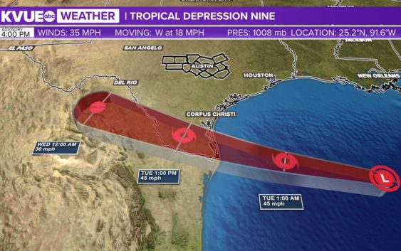
This system brings beneficial rainfall to parts of south Texas, but the vast majority of this stays south of the KVUE area.
AUSTIN, Texas — Tropical Storm Harold has officially formed in the Gulf of Mexico and is expected to make landfall in South Texas Tuesday morning.
Tropical Storm Warnings have been issued for parts of the South Texas Gulf coast, but the beneficial rainfall associated with this system is on track to miss the KVUE area entirely.
We do have a 20% chance for rain with the outer most bands Tuesday afternoon and evening, but we still expect the vast majority of Central Texas to stay hot and dry.
The latest hi-res model data shows widespread rain and windy conditions over south Texas through most of the day on Tuesday. The northern most outer bands will try to work towards the southern tier of the KVUE area, but again don’t plan on much rain making it this far north.
A widespread 2″ to 4″ of rain is likely for much of south Texas. There could be some localized flooding issues, but these areas are also in need of rain due to current drought conditions.
Again, plan on nearly all of the significant rain to miss the KVUE area.
The only wrinkle in the forecast is the very low chance for a spin-up tropical tornado for the southern tier of our area. The main risk for this will stay to our south, but it’s something we can’t completely rule out.
In Central Texas, we get a very meager cool down as this system grazes by to our south. We still expect Austin to reach a high of 101 degrees, extending our all-time record long streak of 45 consecutive days of triple digit heat.
However, added cloud cover and small rain chances should help keep the southern tier of our area in the mid to upper 90s for at least one day.
Despite the lack of rain, it will certainly be breezy on Tuesday with wind gusts up to 30 miles per hour possible. This means more critical fire danger, and a Red Flag Warning is in effect for Tuesday afternoon and evening. Please continue to be mindful of outdoor burning, and anything that could indirectly result in a spark.
High pressure moves closer to Central Texas for the middle and end of this week, so serious heat will quickly resume. High temperature will be in the 107 to 108 range for Thursday through the weekend.
The KVUE Weather Team will continue to closely monitor this developing forecast.
In the meantime, the extended forecast can be found below: