- As wildfires grip South Carolina, governor warns: Burn and you’ll go to jail
- Hundreds of brush fires burn across North Carolina Saturday; several fires still burning Sunday
- Texas’ biggest wildfire started a year ago. How does the Panhandle look now?
- To her, Hurricane Helene debris isn’t trash. It is full of memories — and she’s returning them
- Bills introduced a year after state’s largest blaze seek to limit wildfires
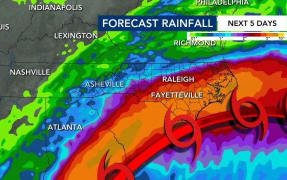
'Extremely dangerous:' Hurricane Idalia makes landfall as Category 3, begins trudge towards NC
TAMPA, FLA. — Hurricane Idalia made landfall in Florida as an extremely dangerous Category 3 storm around 8 a.m. on Wednesday.
Hurricane Idalia will begin pushing north along the coasts of Georgia, South Carolina and North Carolina, where residents are urged to remain vigilant of floods, strong winds, tornadoes and power outages.
As of 9 a.m., Idalia weakened to a Category 2 storm as it began trudging across land.
North Carolina under State of Emergency, Tropical Storm Warning
Governor Roy Cooper has issued a State of Emergency for North Carolina, and a Tropical Storm Warning has been issued for our coastline.
Flash Flood Warnings are also in place for much of the viewing area, including the Triangle.

Idalia brings potential for heavy rain, power outages and gusty winds up to 30 mph in the Triangle, but up to 55 mph by the NC coast. The Triangle could see up to 3 inches of rain, and the coast could see up to 8 inches.
A Tropical Storm Watch is likely to be issued for the Triangle.
Coastal North Carolina will see the biggest impact from Idalia. The greatest threat is for flooding, especially flash flooding through Friday morning.
A tropical storm watch is in effect for parts of the NC coast from the South Carolina line to Surf City. Gov. Roy Cooper issued a state of emergency to help the state prepare for Idalia’s impact.
This media cannot be viewed right now.
Timing: NC impacts from Idalia
On Wednesday we could begin seeing early impacts from Hurricane Idalia. Futurecast shows a band of heavy rain moving across the viewing area starting around 5 p.m. on Wednesday and lingering throughout the evening into Thursday morning.
Some scattered showers will be likely Wednesday around lunchtime, but the heaviest rain will arrive for the evening commute.
Rainfall impacts will be greatest at the coast and southeast of the Triangle, Gardner said. The coast could see between 4 to 8 inches of rain, and southeastern counties could see between 3 to 6 inches. The Triangle could see between 2 to 4 inches of rain, and northern counties could see as little as 1 inch.
Flooding will be the biggest risk locally, from the Triangle to the coast, Gardner said.
The Triangle could see winds gusting up to 35 mph, and there’s potential for flooding and power outages in the viewing area.
A tropical storm watch is already in effect for parts of the N.C. coast, and the watch could extend to the Triangle by Tuesday evening.
Thursday morning will be messy and rainy before Idalia begins to pull away, according to Gardner.
Florida residents hunker down ahead of Idalia
“You still have time this morning to make your final preparations … but you gotta do that now.” Gov. Ron DeSantis announced at the state’s emergency operations center. Tolls have been waived on highways out of the danger area, shelters have opened, hotels are prepared to take evacuees and more than 30,000 utility workers are being staged to make repairs as quickly as possible in the hurricane’s wake, he said.“You do not have to leave the state. You don’t have to drive hundreds of miles. You have to get to higher ground in a safe structure. You can ride the storm out there, then go back to your home,” DeSantis said.
“Right now, the biggest hazards are storm surge,” Robbie Berg, a senior hurricane specialist at the National Hurricane Center in Miami, said Tuesday morning. “We’re expecting a surge as much as 8 to 12 feet above normal tide levels in portions of the Big Bend area of Florida.”
Idalia thrashed Cuba with heavy rain, especially in the westernmost part of the island, where the tobacco-producing province of Pinar del Rio is still recovering from the devastation caused by Hurricane Ian. Residents were evacuated to friends’ and relatives’ homes as up to 4 inches (10 centimeters) of rain fell, meteorological stations reported.
Idalia is the first storm to hit Florida this hurricane season, but only the latest in a summer of natural disasters, including wildfires in Hawaii, Canada and Greece; the first tropical storm to hit California in 84 years, and devastating flooding in Vermont.
Florida airports close; expect delays along east coast
Many school districts along the Gulf Coast said they would be closed Tuesday and Wednesday. Several colleges and universities said they would close their campuses on Tuesday, including the University of Florida in Gainesville.
“They told us that our dorm building, especially, is prone to flooding,” said Erin Amiss, a student at Eckerd College in St. Petersburg.
MacDill Air Force Base, located on Tampa Bay, is preparing to evacuate several aircraft and began a mandatory evacuation Monday morning for personnel who live in local counties, the Air Force said in a statement.
The National Oceanic and Atmospheric Administration recently said the 2023 hurricane season would be far busier than initially forecast, partly because of extremely warm ocean temperatures. The season runs through Nov. 30, with August and September typically the peak.
___
Associated Press contributed to this report.