- Western NC wildfire risk will 'get worse, not better' Ag Commissioner says, pressing lawmakers for help
- Watering trees is a must to protect them from severe weather and drought
- At least 4 dead, hundreds rescued after deadly floods ravage South Texas
- Today on Texas Standard: Deadly floods swamp South Texas, shatter records
- North Carolina radio station was a critical lifeline after Hurricane Helene. Then it became the voice of recovery.
Idalia makes landfall as powerful Category 3 hurricane; how it will affect the Carolinas

Idalia made landfall in Florida as a Category 3 hurricane with sustained winds near 125 mph. It could produce heavy rain, high winds and flooding in the Carolinas.
CHARLOTTE, N.C. —
Idalia update
Idalia (ee-DAL-ya) made landfall along Florida’s Big Bend area around 7:45 a.m. Wednesday as a Category 3 hurricane. Idalia had estimated wind speeds of around 125 mph, according to the National Hurricane Center. Idalia’s landfall happened in Taylor County, which is near the city of Perry.
Water levels along the Big Bend are rising rapidly with a reported level of 5.9 feet in Cedar Key. Idalia could create devastating or catastrophic storm surges in coastal areas up to 10 feet.
Idalia is the second major hurricane in the Atlantic Basin. Florida’s Big Bend is the coastal area between the panhandle and peninsula of the state.
Idalia officially became a hurricane at 5 a.m. Tuesday and quickly strengthened to Category 2 status by 5 p.m. As the storm moved north over warm waters in the Gulf of Mexico, it rapidly intensified to Category 4 status at one time Wednesday before coming ashore as a Category 3.
Areas along the Florida coastline could experience storm surge upwards of 12 feet along the Big Bend, and Tampa Bay could experience storm surge up to 9 feet.
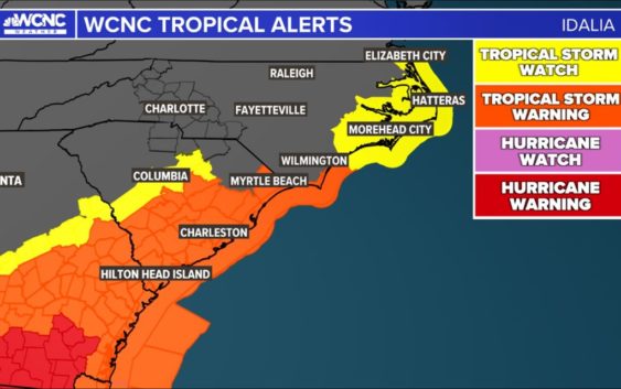
The impacts from Idalia will be far-reaching after landfall. Georgia, South Carolina and North Carolina are all preparing for flooding rainfall, tropical storm force winds and storm surge among other coastal impacts.
The first outer bands from Idalia reached southwest Florida Tuesday afternoon. The storm will make its closest approach to the Charlotte area late Wednesday as it passes to the east based on the latest data. Meanwhile, expect waves of heavy rainfall and localized flooding before the tropical system arrives between Wednesday and Thursday.
South Carolina and North Carolina Coastal Impacts
Storm surge is one of the main impacts for communities along coastline of South Carolina and North Carolinas. The oceanfront along the Charleston area in the Low Country could experience storm surge at 2-4 feet. That is wind driven water pushed ashore will lead street flooding and potential homes and businesses will flood. Areas from Myrtle Beach, Wilmington and along the Outer Banks of N.C. could see a storm surge of 1-3 feet.
For the latest weather alerts, download the WCNC Charlotte mobile app and enable push notifications.
There’s still notable uncertainty with the track. Please stay tuned for updates from the WCNC Charlotte Weather Team.
Hurricane Franklin (First Category 4 hurricane of the season)
Franklin is not making the headlines since it will no affect land. It already crossed Hispaniola as a tropical storm but will not threaten land at its strongest. It just got done with its “rapid intensification” that Idalia will go through next. Franklin may be producing life-threatening surf and rip currents along the southeast coast.
This hurricane is officially the 130th documented category 4 hurricane and currently the strongest of the 2023 Atlantic Hurricane Season.
Contact KJ Jacobs at kjacobs3@wcnc.com and follow him on Facebook, Twitter and Instagram.
Contact Brittany Van Voorhees at bvanvoorhe@wcnc.com and follow her on Facebook, Twitter and Instagram.
WCNC Charlotte’s Weather IQ YouTube channel gives detailed explainers from the WCNC Charlotte meteorologists to help you learn and understand weather, climate and science. Watch previous stories where you can raise your Weather IQ in the YouTube playlist below and subscribe to get updated when new videos are uploaded.