- Seven months after Hurricane Helene, Chimney Rock rebuilds with resilience
- Wildfire in New Jersey Pine Barrens expected to grow before it’s contained, officials say
- Storm damage forces recovery efforts in Lancaster, Chester counties
- Evacuation orders lifted as fast-moving New Jersey wildfire burns
- Heartbreak for NC resident as wildfire reduces lifetime home to ashes
Hurricane Idalia brings tornadoes, rough surf to NC; home loses roof near Myrtle Beach
Hurricane Idalia turned streets to rivers in Florida, Georgia and South Carolina as it moved up the coastline.
Idalia impacted North Carolina as a tropical storm, with the biggest impacts east of Interstate 95 to the coast, where close to 7 inches of rain fell.
Between Tuesday and Thursday, the WRAL Storm Tracker followed the storm from Florida to South Carolina, driving more than 1,300 miles.
See photos of storm damage in NC and SC
Roof blown off near Myrtle Beach
Some of the most severe damage occurred Thursday in Cherry Grove near Myrtle Beach, where an unconfirmed tornado ripped a roof off a beach house. The roof blew behind the house and into a canal.
The homeowner, who lives in Southern Pines, was there when it happened. He said he was watching television when he received the tornado warning. When he opened his front door to move to the ground floor for shelter, he said his roof blew off “within seconds.”
The man was uninjured, although part of the roof fell on top of him. His home was destroyed.
The National Weather Service will be in the Cherry Grove area Thursday to survey the damage.
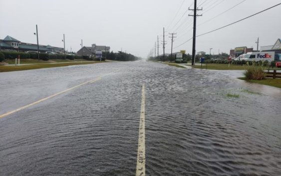
Flooding brief along NC coast
WRAL reporters were stationed in Cumberland and Lee counties and along the NC coast, where our beaches saw the worst conditions late Wednesday and early Thursday.
Due to high surf and wind gusts, streets in Ocean Isle Beach were flooded by 4 p.m. on Wednesday as Idalia hugged the coast, dropping heavy rain. Flooding conditions were already improving at the coast Thursday morning.
Maximum wind gusts recorded at the coast were 56 mph in Wrightsville Beach and 52 mph in Wilmington. Locally, winds gusted as high as 39 mph in Fayetteville.
Tornadoes spotted in Brunswick County
In Brunswick County on Wednesday, two confirmed tornadoes touched down. One tornado was spotted on N.C. Highway 211 near St. James. Video shared on Facebook by the sheriff’s office shows the dark funnel cloud.
The ceiling and roof at Four Paws Veterinary Hospital in Southport was badly damaged in the storm, and cleanup was underway Thursday morning as the worst winds and rain moved away.
In Ocean Isle Beach, most residents escaped major flooding and structure damage, although at least 5 inches of rain fell in 24 hours, causing isolated flooding in low-lying neighborhoods and homes near the sound. Storm debris also littered the beach and roads.
High surf remains dangerous for Labor Day weekend
In Wrightsville Beach and Ocean Isle, people were walking on the shores Thursday morning as the rain pulled away. According to WRAL meteorologist Anthony Baglione, the rain should move away from the coast completely late Thursday afternoon, although much of southeastern North Carolina remains under a flood watch until Friday.
Steven Still, director of emergency management for New Hanover County, said conditions were improving Thursday afternoon.
He urged people to be cautious in and about the water.
“If you are uncomfortable with your swimming abilities, don’t venture out,” Still said.
Bacteria, rip currents both risks for NC beaches
Headed to the beach for the holiday weekend? North Carolina is asking people to stay out of coastal waters from Wright Memorial Bridge in Kitty Hawk all the way to the South Carolina state line due to stormwater runoff, which could contain harmful levels of bacteria.
Excess rain from Idalia forced some cities to pump floodwaters into the ocean, and people should “avoid swimming near ocean outfalls, including the wet sand where the floodwater is pumped, even if no sign is posted,” according to the state.
As conditions continue to improve and Labor Day weekend arrives, there is some good news for beachgoers and people staying in the Triangle. Friday and the weekend will be dry, clear and sunny, with cooler highs in the 80s.
Between Hurricane Franklin and Tropical Storm Idalia, the main threat at the coast will be dangerous rip currents. It’s a good idea to stay out of the ocean this weekend, WRAL meteorologists cautioned.
Rain totals for Tropical Storm Idalia
Idalia did not cause many trees to fall east of the Triangle, even at the coast.
In Fayetteville, some trees fell, and low-lying areas were flooded Wednesday night, especially in Festival Park due to Cross Creek overflow.
According to WRAL meteorologist Elizabeth Gardner, rainfall estimates in central NC as of Thursday morning were:
- Triangle: 1.1 inches
- Rocky Mount/Wilson: 2 inches
- Goldsboro: 3 inches
- Fayetteville: 3.03 inches
- Clinton: 3.77 inches
Much higher rain totals fell at the coast, including totals up to 7 inches in Southport. In Myrtle Beach on Wednesday, the tide gauge was above 9 feet, the sixth highest tide on record since 1987.
At one point, more than 26,000 customers were without power in North Carolina. By 11 a.m. on Thursday, outages in North Carolina were under 11,000, with most outages in coastal communities.