- Fake job seekers are flooding the market, thanks to AI
- One set of evacuation orders lifted in Caldwell County after wildfire contained
- 'We gutted every building' | Chimney Rock rebuilding after Hurricane Helene
- 'We gutted every building' | Chimney Rock rebuilding after Hurricane Helene
- Debris from Hurricane Helene provides fuel, complicates containment for spring wildfires
Hurricane Lee to miss Cape Fear, still deliver beach impacts
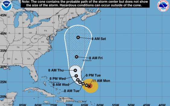
WILMINGTON, NC (WWAY) — Major Hurricane Lee is forecast to miss the Cape Fear but the coast will still see impacts.
As Lee turns to the north in the coming days, it is forecast to weaken but remain a hurricane as it moves between the Carolinas and Bermuda.
Despite being hundreds of miles out in the ocean, Lee will send swell-generated waves of six to nine feet towards east facing beaches.
The National Hurricane Center says a High Surf Advisory may be needed Wednesday through Friday. Rip currents will be very dangerous as well.
Minor beach erosion and over wash will be possible during high tide.