- Fake job seekers are flooding the market, thanks to AI
- One set of evacuation orders lifted in Caldwell County after wildfire contained
- 'We gutted every building' | Chimney Rock rebuilding after Hurricane Helene
- 'We gutted every building' | Chimney Rock rebuilding after Hurricane Helene
- Debris from Hurricane Helene provides fuel, complicates containment for spring wildfires
Tracking Lee as hurricane season peaks
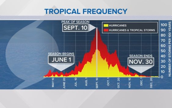
The WCNC Charlotte Weather Team continues to monitor the tropics on the peak of hurricane season.
CHARLOTTE, N.C. — Hurricane Lee is now a Category 3 on the Saffir Simpson Hurricane Wind Scale with max sustained winds of 115 mph.
Lee maxed out at Category 5 intensity last week with winds of 165 mph. This makes it the strongest hurricane of the 2023 season so far. Fluctuations in intensity is common with hurricanes and tropical storms, in this case due to increased wind shear interrupting the storm’s center.
On the Saffir Simpson hurricane wind scale, a major hurricane is a hurricane with winds of at least 111 mph, which is equivalent to Category 3 or higher.
With the storm’s track towards the north and west, our team continues to closely monitor the storm’s long-term path over the week ahead. As the storm slows down and eventually makes the turn to the north, we’ll have a better idea of where it’ll go.
The National Hurricane Center even noted the level of uncertainty in their discussions on the storm. It is too early to know what, if any, impact there is to the U.S., Canada, or Bermuda this week. What we can tell folks in the Carolinas: 1) there is no model showing a Carolina landfall; and 2) the storm will produce dangerous beach conditions and elevated rip currents next week. How bad those conditions are will depend on the proximity of the storm.
“I want everyone to keep paying attention to it, but no, you should not be worried or freaking out about anything yet,” Panovich said. “It’s still so far out and still uncertain at those time ranges.”
Spaghetti models
The storm’s projected path has garnered attention because of the possibility it could impact the East Coast of the United States. As Panovich explained, even with the complete spaghetti model data, it is still too early to know where the storm will go. However, confidence is increasing that the hurricane will stay offshore of the Carolinas by the end of the week.
The WCNC Weather Team notes there have been a few model shifts west, but the shifts back-and-forth are common with hurricane and tropical storm forecasting. There is a lot of uncertainty past five days because Lee is expected to slow down and potentially stall.
Like spaghetti models that predict a storm’s path, there are also intensity models that predict a storm’s strength. These models continue to show a powerful hurricane through next week, regardless of wind speed.
Key factors to watch
Hurricane Lee’s projected forecast path scenarios
Forecasting a hurricane’s path is complicated. For Lee, one of the biggest questions to answer is, “When will the storm begin to turn north?”
Driven by a powerful high pressure system over the Atlantic Ocean and a dip in the jet stream over the United States, Lee will eventually turn north.
There are three main scenarios:
- A turn sooner makes the risk greater for Bermuda but lesser for the United States.
- A turn later means a greater for North Carolina, South Carolina, and the U.S. coastline.
- A just-as-likely scenario means the storm could move safely between Bermuda and the United States with minimal impacts on land.
Even with the latter scenario, Chief Meteorologist Brad Panovich says Lee is “splitting the uprights and too dang close [for comfort].”
What’s next
Model runs, which are published numerous times a day, will soon have clearer visibility into when that northward turn could happen. Even when that begins to appear in the computer models, such a turn would still be days away.
“Big storms are like big ships, they don’t turn on a dime,” Panovich explained. “The sooner you start to see this storm drifting north and making that turn, the better. We don’t want it to wait to the last minute because they tend to struggle to do that.”
The turn can clearly be seen in the latest hurricane tracks from the National Hurricane Center.
Social media rumors
With the storm still more than 2,000 miles from any portion of the continental U.S., there is still a lot of time for speculation and rumors.
Panovich responded this week to rumors posted to social media about the storm. Panovich, who has been forecasting weather in the Carolinas since 2003, disputes any claims – this early on – that the storm is going to make landfall in any particular place.
“So watch where and who you get information from about this storm,” he said. “There is more misinformation on this one.”
For the latest weather alerts, download the WCNC Charlotte mobile app and enable push notifications.
The historical peak of hurricane season is Sept. 10. Hurricane season ends on Nov. 30.
It never hurts to be prepared. Having an emergency supply kit, whether for this storm or a future storm, is a great way to get prepared ahead of any natural disaster.
Contact Brad Panovich at bpanovich@wcnc.com or follow him on Facebook, X and Instagram.
Contact Brittany Van Voorhees at bvanvoorhe@wcnc.com and follow her on Facebook, X and Instagram.
Contact KJ Jacobs at kjacobs3@wcnc.com and follow him on Facebook, X and Instagram.
WCNC Charlotte’s Weather IQ YouTube channel gives detailed explainers from the WCNC Charlotte meteorologists to help you learn and understand weather, climate and science. Watch previous stories where you can raise your Weather IQ in the YouTube playlist below and subscribe to get updated when new videos are uploaded.