- Western NC neighborhood still reeling from Hurricane Helene flood damage
- Ashe County Schools reopen after Hurricane Helene hit area over a month ago
- Ashe County Schools reopen Tuesday after Hurricane Helene hit area
- Carolina Hurricanes foundation donates $50,000 to rebuild Asheville hockey rink
- Stress, shelter, and safety: Hurricane Helene's effect on domestic violence victims in NC
What the rest of hurricane season could look like after tropics have been active recently

The Atlantic Hurricane Season reached its climatological peak on Sept. 10, but that doesn’t necessarily coincide with less activity to come.
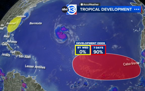
So far, there have been 14 named storms this season, with the latest storm Nigel strengthening into a hurricane Monday.
This makes for an above-average and active season, as we typically don’t reach that number of named storms until November. And with a little over two months left in the season, here’s a broad overview of what the rest of this hurricane season could look like as of Sept. 18.
For the past three weeks, there was a noticeable increase in activity in the Atlantic after a quiet stretch that lasted from late July to late August. ABC13 Meteorologist Elyse Smith previously reported on this, noting the influence of the Madden Julien Oscillation (MJO). To recap, the MJO is a wave pattern that expands across the entire globe and slowly moves from west to east. As it does, it can influence local weather patterns, especially in the tropics, through areas of rising or sinking motion.
RELATED: NOAA forecasters now predict above-average hurricane season for 2023
Throughout the month of September, an area of rising motion has been over the Atlantic Ocean, which aided in tropical development. The result: eight tropical storms developing in the Atlantic, with two locally in the Gulf of Mexico. That’s 10 storms in less than a month.
Most of the activity has been in the central/eastern Atlantic, with several of those storms taking similar paths through the middle of the ocean. This is also reflective of a typical El Niño season, with storms developing further west off the coast of Africa and staying east of the Caribbean and Gulf of Mexico.
Now, there are some signs that tropical activity in the Atlantic could slow down over the next few weeks but not go away entirely. The MJO is hinting that an area of sinking motion, currently located over the eastern Pacific and limiting tropical development there, could move over Central America and to the Caribbean and portions of the deep tropics in late September. While this wouldn’t limit activity entirely across the Atlantic, it could keep the tropics quiet in the Gulf of Mexico and the Caribbean. But constant wind shear from the jet stream will likely keep things quiet across the Gulf regardless for the rest of the month.
However, long-range climate models are also hinting that the MJO could enter a different phase in early October. If so, the rising motion of Central America and options of the Caribbean could aid any tropical development if it were to happen. Plus, it’s also the time of year we monitor the Bay of Campeche for any areas of low pressure that could develop and become something tropical. It’s definitely something to watch, but there’s no cause for alarm right now.
For more on this story, follow Elyse Smith on Facebook, Twitter and Instagram.