- Report: Coastal flooding could threaten 1.4 million homes by midcentury
- Caught on camera | Tornado touches down in Missouri
- Carolina Hurricanes playoff tickets go on sale next week
- Storms kill 6 in the South and Midwest as forecasters warn of catastrophic rains, floods this week
- Weather Impact Alert: Cold front could trigger severe weather in Houston area this weekend | See timeline
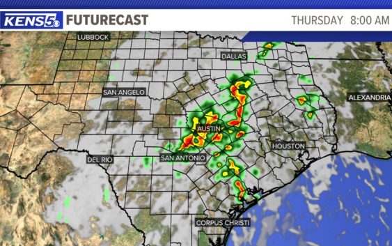
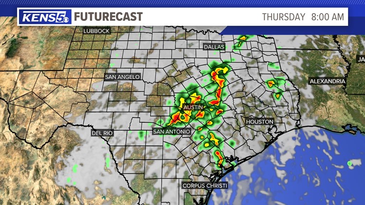
WEATHER ALERT: Tornado Warning in Comal, Hays counties; Flood Watch for parts of the Hill Country
SAN ANTONIO — A Tornado Warning is in effect for portions of Comal and Hays counties until 9:45 a.m. Thursday, according to the National Weather Service. Take cover immediately if you are in these areas!
A Flash Flood Watch is in effect for Bandera, Blanco, Edwards, Burnet, Gillespie, Kendall, Kerr, Llano and Real counties through 1 p.m. Thursday afternoon.
Showers and thunderstorms are expected to continue across portions of the Hill Country through Thursday afternoon.
A moist and unstable airmass is in place and the area continues to receive remnants of a tropical cyclone help produce rainfall totals around 1 to 3 inches. Some isolated spots could receive over 4 inches overnight through Thursday.
For those isolated spots where heavy rainfall can occur could lead to an impact for the morning commutes in the Hill Country and along parts of the I-35 corridor.
By Thursday afternoon a drier airmass will move through the area dropping rain chances to around 20 percent. An active weather pattern continues on Friday and drops again for the weekend.