- Texas’ biggest wildfire started a year ago. How does the Panhandle look now?
- To her, Hurricane Helene debris isn’t trash. It is full of memories — and she’s returning them
- Bills introduced a year after state’s largest blaze seek to limit wildfires
- A year after Texas’ largest wildfire, Panhandle residents tugged between hope and anxiety
- Another $500M for Hurricane Helene relief in North Carolina passes key hurdle
Severe weather possible Tuesday as storms move across Carolinas, Brad Panovich says

Tuesday’s rain is a huge relief for drought-stricken areas but Brad Panovich says a line of storms could produce severe weather in the Charlotte area.
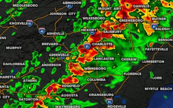
CHARLOTTE, N.C. — The Charlotte area is getting some much-needed rain Tuesday but Chief Meteorologist Brad Panovich is also tracking the threat of severe weather across the Carolinas.
The biggest threats will be heavy rain, damaging winds and isolated tornadoes late Tuesday afternoon and into the evening, according to Panovich. The key to the severe weather setup is if there’s any warmup between periods of rain on Tuesday afternoon. Simply put, the warmer the temperature gets, the greater the risk of strong thunderstorms.
As of 1 p.m., Charlotte recorded 1.1 inches of rainfall, according to Panovich. In the previous 80 days, Charlotte had only received 1.95 inches.
Panovich says a warm front will be pushing through with a wave of rain around 3 p.m. The timing of that front will dictate whether Charlotte and surrounding areas see severe weather.
“If that sets up ahead of this, then this line moving in could have the potential to be strong or severe,” Panovich said. “If the lingering clouds and drizzle keep the atmosphere stable, and the warm front doesn’t push north, then that would keep us a little bit more on the side of just good, old-fashioned rain. But that looks like a pretty potent like by 4 or 5 o’clock trying to move into the mountains and slowly into the Piedmont.”
Storm timing
Panovich said the line of showers and storms will move into western North Carolina around 4 p.m. Tuesday. It will then track over the foothills before making its way to the Piedmont and Charlotte metro area by 8 p.m.
3-5 p.m.: Blowing Rock, Boone, Jefferson
4-6 p.m.: Hickory, Lenoir, Morganton, Taylorsville
6-8 p.m.: Charlotte, Concord, Fort Mill, Gastonia, Huntersville, Lincolnton, Mooresville, Pineville, Rock Hill, Shelby, Waxhaw
Panovich and meteorologist Chris Mulcahy agree the biggest risk will be in areas south and east of Charlotte. Those areas include Monroe, Rockingham, Lancaster, Wadesboro and Cheraw.
Storm threats
The biggest risk will be straight-line winds, but Panovich said you can’t rule out an isolated tornado if the conditions are just right.
“It’s a small tornado risk, the risk overall is pretty low but the wind risk could be pretty high as that pushes in from the west,” Panovich said.