- Here’s how Austin-area leaders are preparing for wildfire threats this summer
- Harris County sues Trump administration, cites threat to hurricane season preparedness
- Prescribed burn in Morrow Mountain aims to prevent future wildfires
- Prescribed burns aim to prevent wildfires in Stanly County
- Prepare for hurricane season with the Town of Leland Hurricane Expo
Texas flooding threat: Emergency officials prepare for heavy rains

Texas leaders said they activated their response resources, which include emergency personnel from several different agencies along with equipment on standby.
HOUSTON — Due to potential flooding, local and state leaders are preparing now to help keep Texans safe.
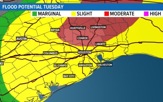
Our KHOU 11 meteorologists are tracking heavy rain expected to arrive Tuesday night and so is the Harris County Flood Control District.
On Tuesday, morning Teams from HCFCD were in the Waller County area to measure water levels at Threemile Creek, which connects to Spring Creek in Harris County.
They focus first on the areas that have had the most rainfall, hydrologic technician Ron Havran told us.
His team put a radar boat in the waterway that sends out a beam to the bottom of the surface water to measure the volume of water and how swiftly it’s moving. A waterproof computer connects to the radar to deliver the data.
“Different colors show the different velocity. So, as the boat goes across the channel, it’s going to measure velocity and depth of water,” Havran explained. “That’s the two main things it’s taking.”
That information is then transferred to the National Weather Service West Gulf River Forecasting Center in Fort Worth. They do all the flood forecasting for the state of Texas and southern region to help residents prepare.
“They can check their neighborhoods. They can sign up on the website for alarms for possibility for flooding or flooding that is occurring,” Havran said. “I would suggest everyone check that map out and find out what gages they are near and what channels they are affected by.”
That map of neighborhoods near Harris County waterways can be found at hcfcd.org.
Texas prepares for potential flooding
The Texas Division of Emergency Management, also known as TDEM, has increased the readiness level of the Texas State Emergency Operations Center to Level II (Escalated Response). They’ve activated additional state emergency response resources as the state prepares for continued heavy rainfall and flash flooding threats this week.
“TDEM and Texas Emergency Management Council agencies are prepared to support needs of local officials as rain and flooding threatens the area along the Interstate-35 corridor as well as East and Southeast Texas,” Texas Emergency Management Chief Nim Kidd said Tuesday.
This helps representatives from all state agencies that are a part of the Emergency Management Council in Texas efficiently be in a better place to respond to the hardest hit local communities.
“Bring them all together, make sure we got everyone in the room helping to coordinate these resources,” said Wes Rapport, media communications officer with Texas Division of Emergency Management. “Brings that heighten sense of awareness for all of our state agency partners as well. This is turning up the dial a bit and making sure everybody is ready.”
For example, Texas Parks and Wildlife have game wardens and boats will be available if needed. That goes the same for the Texas Department of Public Safety and its tactical marine unit with helicopters with voice capabilities.
Also, swift water boat squads from the Texas A&M Task Force are ready to use.
Officials want Texans to be ready for anything. TDEM is asking the community to avoid driving through water if they see some on the roads. Also, they are urging you to have an emergency supply kit in your home and car, including things like water, a flashlight, and food.