- McDowell County wildfire spreads to 500 acres, evacuation orders in place
- Evacuations in Caldwell County due to wildfire
- Northwest Houston 'ghost neighborhood' caused by repeated flooding to become latest detention basin
- NHL playoffs: Hurricanes open playoffs Easter Sunday afternoon vs. Devils
- 2 wildfires spreading in rugged terrain in western North Carolina
Check flood warnings for Houston area rivers, creeks; current water levels for bayous and streams

There are flood warnings along parts of the San Jacinto, Trinity, San Bernard and Colorado rivers. Some creeks are also expected to rise out of their banks.
HARRIS COUNTY, Texas — The National Weather Service has issued alerts for several creeks, bayous and rivers in the Greater Houston area. Most flood-related deaths occur in vehicles, according to the National Weather Service, so don’t take any chances.
West Fork San Jacinto River near Humble
Flood warning until early Monday afternoon; moderate flooding continues and many homes in the Northshore subdivision are cut off, the NWS says; flood stage is 49.3 feet; it was at 48.5 feet Wednesday and is expected to crest at 51.7 feet early Friday afternoon.
Trinity River near Goodrich
- Flood warning until further notice; moderate flooding expected; expected to rise above flood stage of 36 feet late Wednesday afternoon and crest at 38.7 feet Thursday morning
San Bernard River
- Flood warning along San Bernard River where moderate flooding is forecast near Boling, East Bernard and Sweeny until early Saturday morning. The San Bernard River is expected to rise above flood stage of 18 feet Wednesday evening to a crest of 22.3 feet early Thursday morning, according to the National Weather Service.
- Moderate lowland flooding begins upstream from the gauge with significant backwater flooding up Peach Creek in Wharton County that will inundate low-lying areas.
- Minor flooding near Sweeny until Friday morning; flood stage is 7 feet; at 8:45 a.m. Wednesday, it was at 9.8 feet and it’s expected to crest to 10.5 feet this afternoon.
- Minor backwater flooding expected up Snake Creek in Fort Bend County.
Colorado River at Columbus
Flood warning until late Thursday with minor flooding forecast; expected to rise above flood stage of 34 feet and crest at 35.7 feet early Thursday.
Peach Creek at Splendora
- Flood warning from Thursday morning to Friday evening when minor lowland flooding is expected. It’s expected to rise above flood stage of 14 feet Thursday morning and crest at 14.4 feet by the afternoon, the NWS says.
Lake Creek at Sendera Ranch Road
- Moderate flooding is forecast from Wednesday evening to early Saturday afternoon; it’s expected to rise above the flood stage of 138 feet to a crest of 142 feet Thursday morning.
Menard Creek near Rye
- Minor flooding forecast from late Wednesday to early Saturday. The river is expected to rise above the flood stage of 20 feet just after midnight tonight to a crest of 21.8 feet early Thursday afternoon.
Harris County Flood Warning System
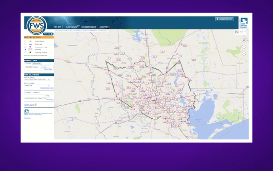
We’ve shown you the Flood Warning System put together by the Harris County Flood Control District before, but now’s a good time to remind you how to use it.
The default map shows 24-hour rainfall totals, but you can toggle the time frame to look at the past two days or just the past 15 minutes.
If you click “channel status,” you can see what kind of impact that rainfall had on bayous. They’re usually all marked green for “no flooding,” but can switch to “flooding possible” or “flooding likely.”
You can also click on an individual gauge to get more information. For example, on the morning of Aug. 27, the gauge at Taylor Lake and Port Road indicated it received 1.60 inches of rain in the previous 24 hours. One tab breaks down that rainfall by the hour, while another tab allows you to monitor stream elevation.
“The goal of our flood warning system is to get the data that we collect at our gauges that measure rainfall and water level into the hands of residents in this region,” says Jeff Lindner, meteorologist for HCFCD. “It’s really a great way to have the information at your fingertips and have what we call situational awareness.”
Below is the map from the Harris County Flood Control District.
The warning system also lets you sign up for alerts in your area. First, you’ll need to register. You can use your Facebook, Google or Twitter accounts — or just sign up with your email and password.
Then you can find the gauges near home or work and sign up for alerts. Those can come via text, email or both.
“A lot of people move around in this area. You can drive in from Fort Bend County to downtown Houston or Kingwood down to Clear Lake,” Lindner says. “You can have heavy rain and flooding in one area and be completely dry and sunny in another area.”
The flood warning system is an easy-to-use tool for any flooding event, including hurricanes. To keep tabs on the Atlantic hurricane system, sign up for ReadyHarris alerts by texting “GULF2021” to 888777.