- McDowell County wildfire spreads to 500 acres, evacuation orders in place
- Evacuations in Caldwell County due to wildfire
- Northwest Houston 'ghost neighborhood' caused by repeated flooding to become latest detention basin
- NHL playoffs: Hurricanes open playoffs Easter Sunday afternoon vs. Devils
- 2 wildfires spreading in rugged terrain in western North Carolina
Experimental changes arriving this summer to National Hurricane Center forecast cone
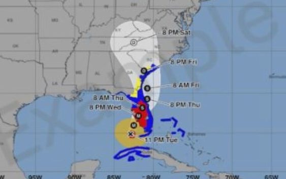
WILMINGTON, NC (WWAY) — The Cape Fear is no stranger to the National Hurricane Center forecast cone.
But some experimental changes are arriving this summer.
Beginning on or around August 15th, a new version of the cone graphic that includes inland tropical storm and hurricane watches and warnings in effect for the continental United States will be issued.
The National Hurricane Center says recommendations from social science research suggest that the addition of inland watches and warnings to the cone graphic will help communicate inland wind risk during tropical cyclone events while not overcomplicating the current version of the graphic with too many data layers.
There will be opportunities to provide feedback during the product’s experimental phase.
The current operational cone graphic will continue to be available, and there will be no changes with respect to how coastal watches and warnings are displayed on that graphic.
Hurricane Season begins in 116, on June 1st.