- Texas’ biggest wildfire started a year ago. How does the Panhandle look now?
- To her, Hurricane Helene debris isn’t trash. It is full of memories — and she’s returning them
- Bills introduced a year after state’s largest blaze seek to limit wildfires
- A year after Texas’ largest wildfire, Panhandle residents tugged between hope and anxiety
- Another $500M for Hurricane Helene relief in North Carolina passes key hurdle
Weather Aware: Severe storms moving into South Carolina, Chester County under Tornado Watch

A strong cold front with a history of widespread damage looks to fuel more strong thunderstorms into the Carolinas.
CHARLOTTE, N.C. — Multiple severe thunderstorm warnings and tornado warnings have been starting the morning east of Atlanta this morning. These storms are flying now anywhere from 40-65 mph to the northeast. The worst of the storms will be in our far southern viewing area.
Chester County, South Carolina, is under a Tornado Watch until 8 a.m.
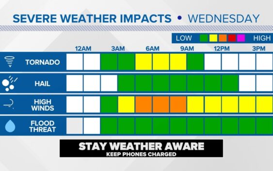
Even though the Watch goes until 8 a.m., the severe storm threat is most likely to arrive between 5-6 a.m.. Per the most recent update, storms will be a lot stronger in central and southern South Carolina, with the impacts to North Carolina, arriving later today in the eastern part of the state.
According to Panovich, the line is expected to roll into the North Carolina mountains by midnight on Tuesday night.
“For the mountains, midnight to 3 a.m. is your timeframe for these storms,” Panovich said. “For the Piedmont, we’re looking at a timeframe of maybe 3 a.m. to 6 a.m., with 6 a.m. plus or minus two hours being the main timeframe to watch.”
Storm timing
- Charlotte metro: 3 a.m. – 6 a.m.
- East of Charlotte: 6 a.m. – 9 a.m.
Storm threats
Some storms could be strong enough to produce severe, damaging winds. While the tornado risk is low, Panovich said you can’t rule them out entirely.
“Definitely charge up your phone and have the volume turned up tonight because we could have some overnight and early morning storms that could pose some issues,” Panovich said.
The threat of storms will come at a time when most people will be sleeping. Devices like a NOAA weather radio can act like a smoke detector by sounding an audible alarm if and when a severe storm approaches your location. Severe weather alerts will also appear on all WCNC Charlotte platforms, including the WCNC Charlotte’s mobile app.
For the latest weather alerts, download the WCNC Charlotte mobile app and enable push notifications.
RAISE YOUR WEATHER IQ: How to receive severe weather warnings
Storm damage elsewhere
This same line of storms produced severe weather west of the Carolinas on Monday and Tuesday. The storm system has prompted storm warnings in locations such as Oklahoma on Monday. The line pushes east through Tennessee and Georgia Tuesday before moving into North Carolina and South Carolina during those predawn hours on Wednesday.
In Kentucky and Indiana, tornadoes are being blamed for storm damage.
Photos of storm damage from Kentucky and Indiana:
Some of the storms could still be around during Wednesday morning’s rush hour commute. The storm threat moves into the coastal areas of the Carolinas later Wednesday.
Panovich will be tracking the developing forecast on WCNC Charlotte Tuesday night. Larry Sprinkle will have updates throughout the storm threat on Wednesday morning.
WCNC Charlotte’s Weather IQ YouTube channel gives detailed explainers from the WCNC Charlotte weather meteorologists to help you learn and understand weather, climate and science. Watch previous stories where you can raise your Weather IQ in the YouTube playlist below and subscribe to get updated when new videos are uploaded.