- Fake job seekers are flooding the market, thanks to AI
- One set of evacuation orders lifted in Caldwell County after wildfire contained
- 'We gutted every building' | Chimney Rock rebuilding after Hurricane Helene
- 'We gutted every building' | Chimney Rock rebuilding after Hurricane Helene
- Debris from Hurricane Helene provides fuel, complicates containment for spring wildfires
Colorado State University releases hurricane season forecast, and it's expected to be a busy one

While the forecast is for an active season, that doesn’t mean one will come to the Texas Gulf coast.
HOUSTON — Colorado State University is out with its forecast for what they believe will be a very busy Atlantic hurricane season.
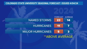
On average, the Atlantic sees about 14 named storms each hurricane season. Of those, seven become hurricanes with three becoming major (Cat-3 or above) storms. The CSU forecast is significantly above that normal. They believe we will see 23 named storms, 11 hurricanes with five of those becoming major hurricanes.
Why such an active season? Dr. Phil Klotzbach, lead forecaster at CSU, says it’s because of two main factors — above normal sea surface temperatures and expected La Niña conditions this summer. The warm water adds more energy to the tropics, making fuel for these storms more available. But perhaps more importantly, La Niña usually reduces vertical wind shear.
Winds blowing across a developing or mature tropical system can keep a budding system from developing and weaken stronger storms. This reduces the total storm count. But when La Niña conditions are in place, this wind shear is often reduced. That, combined with the warm ocean surface temps is why Dr. Klotzbach believes more storms than normal will form.

The CSU forecast is 170%-180% of normal. So what would a busy season like this look like? That’s a very difficult question to answer because there is no way of knowing where all these storms will go. Most could stay out over open water or take aim on the Caribbean, East Coast and Gulf of Mexico.
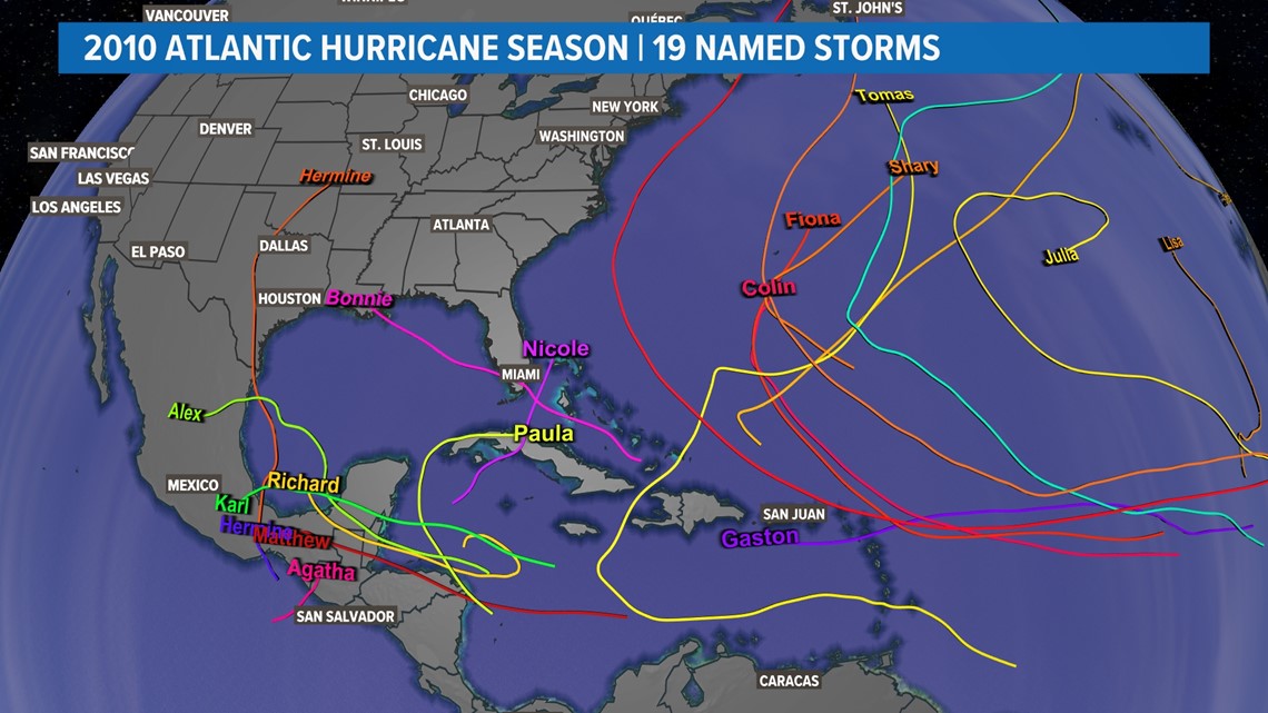
For example, the 2010 Atlantic hurricane season had 19 named storms, 12 hurricanes and five majors. That’s pretty close to what CSU is calling for. Even with that many storms, however, Houston/Galveston did not get one drop of rain from any of them.


“No one can tell you months in advance when or where storms are going to go,” Dr. Klotzbach said. “We always say it only takes one storm. Because obviously it does. You could have a very, very quiet season, like 1983, which obviously had only four storms all year, but the ‘A’ storm formed very late, late August and obviously Alicia was very devastating for the Houston area.”
What we do know is that taking time to talk to your family, friends and neighbors about getting ready for whatever this season brings will save lives. If you live near the coast or Galveston Bay, know your evacuation routes and have a plan and supplies ready to go, now, before the season ever starts. The same goes for our inland residents who may not need to evacuate but will need supplies like food and water for several days in the wake of a big storm.
Watch: Dr. Phil Klotzbach talks to HOU 11 Chief Meteorologist David Paul about the 2024 hurricane season
Most importantly, stay close to the KHOU 11 weather forecast, watch it several times a day and follow our updates online. Things can change and intensify quickly. We don’t always get several days warning. Our team is your trusted source for weather, armed with information on what to expect, so you can keep your family safe.
Colorado State University will issue more forecasts throughout the hurricane season. They will be on June 11, July 9 and August 6. Then they’ll release two-week forecasts on August 20, Sept. 3, Sept. 17, Oct. 1 and Oct. 15.