- Seven months after Hurricane Helene, Chimney Rock rebuilds with resilience
- Wildfire in New Jersey Pine Barrens expected to grow before it’s contained, officials say
- Storm damage forces recovery efforts in Lancaster, Chester counties
- Evacuation orders lifted as fast-moving New Jersey wildfire burns
- Heartbreak for NC resident as wildfire reduces lifetime home to ashes
Weather Aware: Tornado warning issued for 3 counties

A severe thunderstorm watch is in effect for 4 p.m. for areas near Charlotte Wednesday with a Tornado Watch issued for Cleveland, Lincoln and Gaston counties.
CHARLOTTE, N.C. — Severe thunderstorm watches and warnings are in effect for parts of the Charlotte area as a line of strong storms moves across the Carolinas Wednesday afternoon. A Tornado Warning was issued around 3 p.m. for Cleveland, Gaston and Lincoln counties and will remain in effect through 3:45 p.m.
Chief Meteorologist Brad Panovich is monitoring the line of strong thunderstorms that could produce damaging winds and large hail in the Charlotte area from 3 p.m. until 8 p.m. Wednesday. Panovich said the first wave of storms is expected to move closer to Charlotte by 4 p.m. with heavy rain and gusty winds expected. Some of these storms could produce 70 mph winds and 2-inch hail.
The National Weather Service issued a severe thunderstorm watch for the following counties ahead of the storms: Alexander, Burke, Caldwell, Catawba, Cleveland, Gaston, Iredell, Lincoln and Mecklenburg. The watch is in effect until 4 p.m.
A severe thunderstorm warning is in effect for Burke, Catawba, Cleveland, Gaston and Lincoln counties until 3:45 p.m. Panovich said he expects more watches and warnings as the storms push east toward Charlotte. A second line of storms is expected overnight into Thursday.
“These are going to be moving in, but this won’t be the only wave of storms,” Panovich said. “There’s another cluster developing back in Missouri that’s going to be here overnight into early Thursday morning.”
Severe weather threat
Panovich says Wednesday and Thursday are days to be Weather Aware in Charlotte and the Carolinas. This means there is a chance for severe weather that could impact people’s safety and their property. These storms are also expected to impact the Wells Fargo Championship at Quail Hollow.
Large hail and damaging winds are the primary threats from Wednesday’s storms, but Panovich said you can’t rule out isolated tornadoes.
“The damaging wind risk is about 15%, the tornado risk is about 2%, though that could go up or down,” Panovich explained. “The hail probability is a little bit more elevated, 15% if pretty significant.”
Panovich said he won’t be surprised if some areas see 2-inch hail as these storms push across the Carolinas on Wednesday.
Storm timing
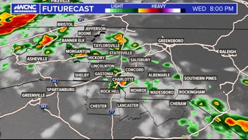
The first line of storms is expected in the North Carolina mountains by noon Wednesday. Areas that will be in the path will include Blowing Rock, Boone and Jefferson. Scattered storms will the move east into the foothills toward Hickory, Marion and Morganton.
After 2 p.m., the scattered storm threat moves into Gastonia, Rock Hill, Fort Mill, Concord and other locations within the Charlotte metro.
“By 4 p.m. it will be arriving in Charlotte,” Panovich said. “This is where I think we’ll probably see a new watch issued for areas around Charlotte and points east, because this is going to stay severe, it’s moving into a very unstable air mass.”

Panovich said there could be an isolated storm or two after 7 p.m. but it should be mostly quiet until midnight into Thursday. The second wave is expected to hit the Charlotte metro around 3 a.m.
A possible third round of storms could occur during the Thursday morning rush hour. Panovich said these waves of storms could produce heavy rain, damaging winds and isolated tornadoes.
Panovich said any Thursday morning storms could impact the Wells Fargo Championship at Quail Hollow Club. The good news is things should clear out by the middle of the day and we’re looking at much nicer weather through the weekend.
“It looks like those storms will have used up so much energy in the atmosphere there may not be time for the atmosphere to reload or get re-intensified because at the same time, there’s a cold front sweeping in,” Panovich said. “So it’s a race to see if things get unstable again before the front or is there not enough time and the front gets in and clears everything out.”
Panovich said it’s looking more likely that the front will arrive first, leading to a sunny, pleasant afternoon in the Carolinas.
WCNC Charlotte To Go is a daily news and weather podcast you can listen to so you can start your day with the team at WCNC Charlotte.
SUBSCRIBE: Apple Podcasts || Spotify || Pandora || TuneIn || Google Podcasts || iHeart
All of WCNC Charlotte’s podcasts are free and available for both streaming and download. You can listen now on Android, iPhone, Amazon, and other internet-connected devices. Join us from North Carolina, South Carolina, or on the go anywhere.