- Wildfire in San Jacinto Co. grows to 1,200 acres, 10% contained
- Wildfire in San Jacinto Co. grows to 700 acres, zero percent contained
- Wildfire in San Jacinto Co. burns at least 200 acres, zero percent contained
- Wildfire burns at least 200 acres, zero percent contained
- Wildfire burning in San Jacinto County | Live video
Another round of storms moves in Thursday after severe weather kills 1 Wednesday
A tornado warning and several severe thunderstorm watches were in effect for areas near Charlotte Wednesday.
Brad Panovich, Hank Lee, James Brierton (WCNC), Brittany Van Voorhees (WCNC), Blair Shiff (WCNC), Chris Mulcahy, Larry Sprinkle, Anders J. Hare (WCNC)
1:50 PM EDT May 7, 2024
9:16 AM EDT May 9, 2024
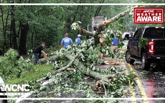
CHARLOTTE, N.C. — One person died and tens of thousands remain without power after severe weather swept across the Charlotte area on Wednesday with more storms possible Thursday.
Multiple severe thunderstorm watches and warnings were issued when waves of strong storms rumbled across the Carolinas Wednesday into early Thursday.
A tornado warning was issued around 3 p.m. Wednesday for Cleveland, Gaston and Lincoln counties. The National Weather Service reported widespread wind damage, including downed trees and power lines in Gaston County. There were also reports of quarter-sized hail in Bessemer City during the storms.
One person was killed in Gaston County when a tree fell on the car. Firefighters were able to rescue another person from the vehicle. A state of emergency was declared in Gaston County due to the widespread damage littering the county.
Numerous school districts canceled classes on Thursday, including Cleveland, Gaston and Lincoln counties. Several Charlotte-Mecklenburg Schools are closed due to power outages in the Queen City.
Wednesday, Thursday storm damage in the Charlotte area
Thursday storm timing
Meteorologist Chris Mulcahy said a third wave of storms is expected to move through on Thursday before things finally clear up by the afternoon. Thursday’s storms will impact the Wells Fargo Championship, with tournament organizers announcing the opening round would be delayed by weather.
Forecaster Larry Sprinkle said the final wave of storms will push through around 10 a.m. Areas along U.S. 74 and Interstate 85 are expected to be impacted. These areas include Shelby, Kings Mountain, Bessemer City, Charlotte, Gastonia and Concord.
Severe weather threat
Chief Meteorologist Brad Panovich says Thursday will be another day to be Weather Aware in the Carolinas. While the severe weather threat isn’t as great in Charlotte, areas south of the Queen City will be at risk for damaging winds, hail and isolated tornadoes.
More Videos
WCNC Charlotte’s Weather IQ YouTube channel gives detailed explainers from the WCNC Charlotte weather meteorologists to help you learn and understand weather, climate and science. Watch previous stories where you can raise your Weather IQ in the YouTube playlist below and subscribe to get updated when new videos are uploaded.
WCNC Charlotte To Go is a daily news and weather podcast you can listen to so you can start your day with the team at WCNC Charlotte.
SUBSCRIBE: Apple Podcasts || Spotify || Pandora || TuneIn || Google Podcasts || iHeart
All of WCNC Charlotte’s podcasts are free and available for both streaming and download. You can listen now on Android, iPhone, Amazon, and other internet-connected devices. Join us from North Carolina, South Carolina, or on the go anywhere.