- Weather Impact Alert: Brad Panovich updates severe weather risk on Sunday
- Big March storm system threatens US with tornadoes, blizzards and wildfire risk
- As city leaders consider expanding at-risk zone for wildfire damage, home builders say it could raise costs
- Is your neighborhood at high wildfire risk? | Here's how to check the city's wildfire risk map
- 'Be prepared now': Brad Panovich updates severe weather risk for Sunday
NWS confirms EF 1 tornado touched down in Cypress area during Thursday's storms
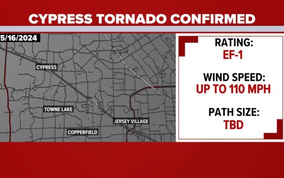
HOUSTON — A tornado did touch down in at least one part of the Houston area last night, according to the National Weather Service.
According oto the National Weather Service, it was an EF-1 with winds of 110 miles per hour. We don’t know the path and how long it was on the ground, but Jeff Evans with the NWS confirmed the tornado touched down in northwest Harris County.
The NWS had teams spread out across the region and Evans told KHOU 11’s Victor Jacobo about the Cypress tornado.
“Our third team just reached out to me.,” he said. “They can confirm we did have a tornado in the northwest part, at the beginning of the storm up near Cypress.”
Evans also said straight line wind at 100 miles per hour moved through downtown Houston and winds between 90 and 100 miles per hour went through the southeast part of the county all the way to Baytown.