- National memorial to honor NC firefighter who died on duty during Hurricane Helene
- Gov. Josh Stein extends State of Emergency for western NC wildfires
- Governor Stein extends state of emergency for NC wildfire threat
- Governor Stein extends emergency in 34 NC counties amid wildfire threat
- Texans can buy emergency preparation supplies tax-free April 26-28 ahead of severe weather season
Tropical rain bands for Central Texas on Wednesday, minor flooding possible
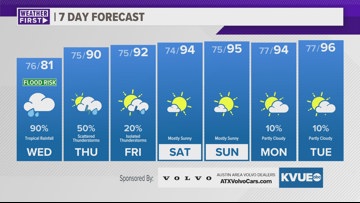
While the rainfall totals have trended down for Central Texas, we’re still expecting a half inch to 3 inches of rain for most with a minor flood risk.
AUSTIN, Texas — Potential Tropical Cyclone One remained loosely organized through the day on Tuesday, and still has not become an official named system. With that being said, the system is producing a large swath of tropical moisture over the Gulf, and during the day on Wednesday some of this moisture will move into the KVUE area.
Unfortunately, local rainfall totals have been trending lower. However, we are still expecting a widespread 0.5″ to 3″ of rain with isolated pockets up to 5″ possible. This will bring a minor flood risk, but likely not any widespread issues like what looked possible a couple days ago.
The latest forecast cone still develops this system into Tropical Storm Alberto prior to landfall in northern Mexico late Wednesday into Thursday morning.
When to expect rain in Central Texas
There will be some spotty tropical downpours during the morning, but the highest rain chances and heaviest rain potential will be during the afternoon and evening on Wednesday. It won’t be raining constantly, but we expect periodic tropical downpours and tropical feeder bands that will bring some gusty winds up to 35 miles per hour and pockets of heavy rainfall.
Activity will gradually wind down Wednesday night into Thursday morning, but a few more scattered tropical downpours will be possible Thursday afternoon and early evening.
Our weather will quickly trend drier Friday into this weekend.
How much rain will fall?
Although the totals have trended down, we’re still expecting some beneficial rain locally. Generally, we are expecting between a half inch and 3 inches of rainfall with isolated totals as high as 5 inches possible. The lower totals will be north of Austin, with a sharp gradient into higher totals along the I-10 corridor.
This amount of rain should not cause widespread issued, but there is still a level 2 of 4 risk for minor flooding for most of the KVUE area.
A Flood Watch is in effect through Thursday afternoon for Caldwell and Fayette counties. This is the zone to watch for pockets up to 5 inches of rain that could cause flooding.
The bottom line for Central Texas
Although this system will not be as impactful as appeared possible a few days ago, we still have tropical rain in the forecast on Wednesday that could create minor flooding. In addition to the flood risk, the Storm Prediction Center has added a low end tornado risk for areas southeast of Austin.
If you live in a traditinally flood prone spot, especially over Caldwell or Fayette counties, make sure you complete your flood preps by Wednesday morning. Also, make sure you are keeping up with the forecast and have a reliable way to get alerts such as the KVUE app.
The KVUE Weather Team will continue to closely monitor this developing forecast.
In the meantime, the extended forecast can be found below:
