- Evacuation orders lifted as fast-moving New Jersey wildfire burns
- Heartbreak for NC resident as wildfire reduces lifetime home to ashes
- ‘It’s only going to get worse’: Wildfire risk grows in western North Carolina
- McDowell County wildfire spreads to 2,085 acres
- Rocky Point wildfire is fully contained
Hurricane Beryl strengthens to category 4 as it continues track to the west
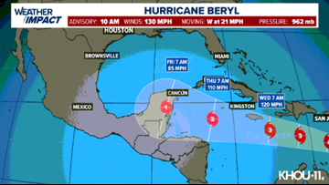
At 10:40 a.m., the storm had maximum sustained winds of 130 mph and was moving to the west at 21 miles per hour.
HOUSTON — Hurricane Beryl has strengthened into a powerful Category 4 storm as it approaches the southeast Caribbean, which began shutting down Sunday amid urgent pleads from government officials for people to take shelter.
Hurricane warnings were in effect for Barbados, St. Lucia, Grenada, and St. Vincent and the Grenadines. Beryl’s center is expected to pass about 70 miles (112 kilometers) south of Barbados on Monday morning, said Sabu Best, director of Barbados’ meteorological service.
CURRENT LOCATION/PATH: With an update at 10:40 a.m. Sunday, Beryl was a Category 4 storm with maximum sustained winds of 130 mph, moving west at 21 mph. (Update in Spanish).
This is the earliest in a calendar year that there’s been a Cat. 4 storm in the Atlantic basin, according to Colorado State University. The previous earliest was July 8, which happened in 2005.
It was expected to pass just south of Barbados early Monday and then head into the Caribbean Sea as a major hurricane on a path toward Jamaica. It is expected to weaken by midweek but still remain a hurricane as it heads toward Mexico.
“This is a very serious situation developing for the Windward Islands,” warned the National Hurricane Center in Miami, which said that Beryl was “forecast to bring life-threatening winds and storm surge.”
Beryl strengthened into a Category 3 hurricane on Sunday morning, becoming the first major hurricane east of the Lesser Antilles on record for June, according to Philip Klotzbach, Colorado State University hurricane researcher.
Beryl is now only the third Category 3 hurricane ever recorded in the Atlantic in June, following Audrey in 1957 and Alma in 1966, said hurricane specialist and storm surge expert Michael Lowry.
“Beryl is an extremely dangerous and rare hurricane for this time of year in this area,” he said in a phone interview. “Unusual is an understatement. Beryl is already a historic hurricane and it hasn’t struck yet.”
Watches and warnings in effect
Hurricane warnings in effect for Barbados, St. Lucia, Grenada, and St. Vincent and the Grenadines.
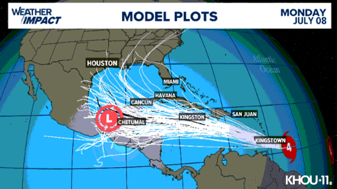
Beryl path

Beryl spaghetti models

Potential threats
Beryl is expected to be a major hurricane when it reaches the Windward Islands early Monday. It’s expected to bring destructive hurricane-force winds and life-threatening storm surge. Heavy rainfall and localized flooding along the Windward Islands is expected late Sunday and Monday.
Track the storm
Hurricane Season links
Hurricane season 2024 forecast
Colorado State University released its forecast update for the 2024 hurricane season, maintaining that it will be a busy one. In April, they predicted that we could see 23 named storms and 11 hurricanes with five becoming major hurricanes. They blame the extremely warm tropical Atlantic and likely “La Niña” as the primary reasons.
RELATED: Colorado State University releases hurricane season forecast update, maintains it will be a busy one
On average, the Atlantic sees about 14 named storms each hurricane season. Of those, seven become hurricanes with three becoming major (Category 3 or above) storms.
Why such an active season? Dr. Phil Klotzbach, lead forecaster at CSU, says it’s because of two main factors — above-normal sea surface temperatures and expected La Niña conditions this summer. The warm water adds more energy to the tropics, making fuel for these storms more available. But perhaps more importantly, La Niña usually reduces vertical wind shear.
Winds blowing across a developing or mature tropical system can keep a budding system from developing and weaken stronger storms. This reduces the total storm count. But when La Niña conditions are in place, this wind shear is often reduced. That, combined with the warm ocean surface temps is why Dr. Klotzbach believes more storms than normal will form.