- 'A little emotional': Hurricanes equipment manager got seconds in goal, memory to last a lifetime
- WMO retires three hurricane names after devastating 2024 season
- Beryl removed from future hurricane naming lists
- Hurricane names Helene, Milton and Beryl are now retired
- Hurricane Helene's name retired after deadly 2024 impact on US
Hurricane Beryl now a Cat. 3 storm as it heads west | TS Chris makes landfall in Mexico
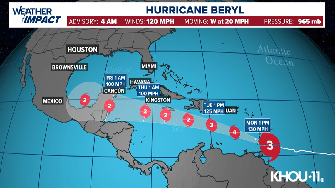
At 4 a.m., Beryl had maximum sustained winds at 120 miles per hour. It’s moving to the west at 20 mph.
HOUSTON — Hurricane Beryl was closing in on the southeastern Caribbean, and government officials late Sunday pleaded with people to take shelter from the dangerous Category 3 storm.
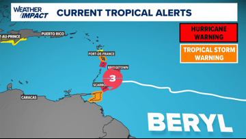
The storm was expected to make landfall in the Windward Islands on Monday morning. Hurricane warnings were in effect for Barbados, St. Lucia, Grenada, Tobago and St. Vincent and the Grenadines.
CURRENT LOCATION/PATH: With an update at 4 a.m. Monday, Beryl was a Category 3 storm with maximum sustained winds of 120 mph, moving west at 20 mph. (Update in Spanish).
“This is a very dangerous situation,” warned the U.S. National Hurricane Center in Miami, saying Beryl was “forecast to bring life-threatening winds and storm surge.”
Beryl was centered about 110 miles (175 kilometers) south-southeast of Barbados early Monday. It had maximum sustained winds of 120 mph (195 kph) and was moving west at 20 mph (31 kph). It is a compact storm, with hurricane-force winds extending 30 miles (45 kilometers) from its center.
It had gained Category 4 strength Sunday before weakening slightly, and further fluctuations in strength were forecast.
A tropical storm warning was in effect for Martinique and Trinidad. A tropical storm watch was issued for Dominica, Haiti’s entire southern coast, and from Punta Palenque in the Dominican Republic west to the border with Haiti.
Beryl was expected to pass just south of Barbados early Monday and then head into the Caribbean Sea as a major hurricane on a path toward Jamaica. It was forecast to weaken by midweek, but still remain a hurricane while heading toward Mexico.
Tropical Storm Chris
The third tropical depression of the Atlantic hurricane season became Tropical Storm Chris in the Bay of Campeche. It’s moving into Mexico, bringing flooding and possible landslides.
Watches and warnings in effect
Hurricane warnings in effect for Barbados, St. Lucia, Grenada, and St. Vincent and the Grenadines.

Beryl forecast cone

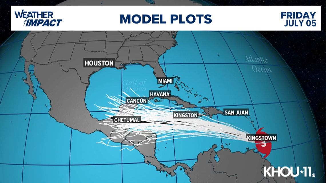
Beryl spaghetti models

Potential threats
Beryl is expected to be a major hurricane when it reaches the Windward Islands early Monday. It’s expected to bring destructive hurricane-force winds and life-threatening storm surge. Heavy rainfall and localized flooding along the Windward Islands is expected late Sunday and Monday.
Track the storm
Hurricane Season links
Hurricane season 2024 forecast
Colorado State University released its forecast update for the 2024 hurricane season, maintaining that it will be a busy one. In April, they predicted that we could see 23 named storms and 11 hurricanes with five becoming major hurricanes. They blame the extremely warm tropical Atlantic and likely “La Niña” as the primary reasons.
RELATED: Colorado State University releases hurricane season forecast update, maintains it will be a busy one
On average, the Atlantic sees about 14 named storms each hurricane season. Of those, seven become hurricanes with three becoming major (Category 3 or above) storms.
Why such an active season? Dr. Phil Klotzbach, lead forecaster at CSU, says it’s because of two main factors — above-normal sea surface temperatures and expected La Niña conditions this summer. The warm water adds more energy to the tropics, making fuel for these storms more available. But perhaps more importantly, La Niña usually reduces vertical wind shear.
Winds blowing across a developing or mature tropical system can keep a budding system from developing and weaken stronger storms. This reduces the total storm count. But when La Niña conditions are in place, this wind shear is often reduced. That, combined with the warm ocean surface temps is why Dr. Klotzbach believes more storms than normal will form.