- Cold front could trigger severe weather in Houston area this weekend | Timeline for potential storms
- Severe weather possible for Houston this weekend | Weather Impact Alert issued
- Impact Plastics not responsible for workers killed in Helene flooding, TOSHA says
- 'A little emotional': Hurricanes equipment manager got seconds in goal, memory to last a lifetime
- WMO retires three hurricane names after devastating 2024 season
Hurricane Beryl remains a Cat. 4 storm as it moves through Caribbean

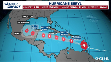
At 4 p.m., Beryl had maximum sustained winds at 150 miles per hour. It’s moving to the west-northwest at 21 mph.
HOUSTON — A dangerous and extremely powerful Hurricane Beryl made landfall Monday on the Caribbean island of Carriacou after becoming the earliest storm of Category 4 strength to form in the Atlantic, fueled by record warm waters.
Winds up to 150 mph (240 kph), just shy of a Category 5 storm, blew off roofs, uprooted trees and caused other damage on Carriacou, one of the islands of Grenada, and elsewhere in the southeast Caribbean.
“This is an extremely dangerous and life-threatening situation,” the U.S. National Hurricane Center said.
Hurricane warnings remained in effect for Grenada and St. Vincent and the Grenadines as thousands of people hunkered down in homes and shelters. The last strong hurricane to hit the southeast Caribbean was Hurricane Ivan 20 years ago, which killed dozens of people in Grenada.
CURRENT LOCATION/PATH: With an update at 4 p.m. Monday, Beryl was a Category 4 storm with maximum sustained winds of 150 mph, moving west-northwest at 21 mph. (Update in Spanish).
NBC Radio in St. Vincent and the Grenadines said it received reports of roofs being torn off churches and schools as communications began collapsing across the southeast Caribbean.
“Jesus Christ!” a woman yells in a video that shows tin roofs flying through the air.
Beryl forecast cone

In nearby Grenada, officials received “reports of devastation” from Carriacou and surrounding islands, said Terence Walters, Grenada’s national disaster coordinator. Prime Minister Dickon Mitchell said he would travel to Carriacou as soon as it’s safe, noting that there’s been an “extensive” storm surge.
Grenada officials had to evacuate patients to a lower floor after hospital roof was damaged, he said.
“There is the likelihood of even greater damage,” he told reporters. “We have no choice but to continue to pray.”
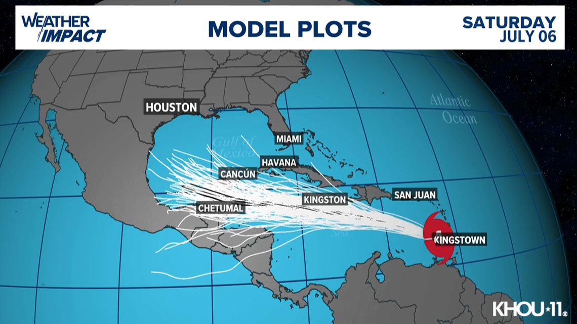
Beryl spaghetti models


On Monday afternoon, Beryl was about 65 miles (105 kilometers) northwest of the island of Grenada, moving west-northwest at 20 mph (31 kph).
In Barbados, officials received more than a dozen reports of roof damage, fallen trees and downed electric posts across the island, said Kerry Hinds, emergency management director. Wilfred Abrahams, minister of home affairs and information, said drones — which are faster than crews fanning across the island — would assess damage once Beryl passes.
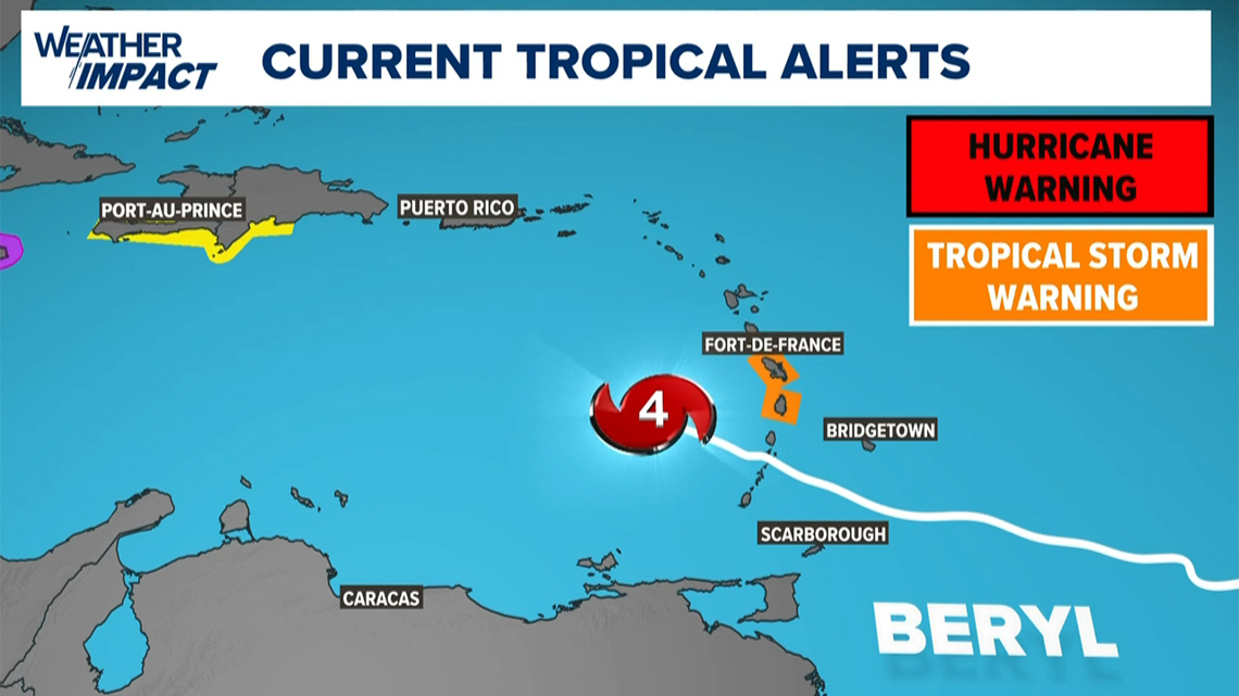
A tropical storm warning was in effect for St. Lucia and Martinique. A tropical storm watch was issued for Haiti’s entire southern coast, and from Punta Palenque in the Dominican Republic west to the border with Haiti. A hurricane watch was issued for Jamaica.
Forecasters warned of a life-threatening storm surge of up to 9 feet (3 meters) in areas where Beryl made landfall, with 3 to 6 inches (7.6 to 15 centimeters) of rain for Barbados and nearby islands and possibly 10 inches in some areas (25 centimeters), especially in Grenada and the Grenadines.
The storm was expected to weaken slightly over the Caribbean Sea on a path that would take it just south of Jamaica and later toward Mexico’s Yucatan Peninsula as a Category 1.
“Beryl is forecast to remain a significant hurricane during its entire trek across the Caribbean region,” the National Hurricane Center said.
Officials in some southeast Caribbean islands announced controlled power outages and warned of water cuts ahead of the storm, as well as landslides and flash floods. Schools, airports and government offices shuttered.
Hours before the storm, Barbadian Michael Beckles said he still feared the worst for his island.
“As prepared as we can try to be, there are a lot of things that we can’t control,” he said. “There are a lot of houses that are not ready for a storm like this.”
Watches and warnings in effect
Hurricane warnings were in effect for Barbados, Grenada, St. Lucia, Tobago and St. Vincent and the Grenadines.A tropical storm warning was in effect for Martinique and Trinidad. A tropical storm watch was issued for Dominica, Haiti’s entire southern coast, and from Punta Palenque in the Dominican Republic west to the border with Haiti.


Track the storm
Hurricane Season links
Hurricane season 2024 forecast
Colorado State University released its forecast update for the 2024 hurricane season, maintaining that it will be a busy one. In April, they predicted that we could see 23 named storms and 11 hurricanes with five becoming major hurricanes. They blame the extremely warm tropical Atlantic and likely “La Niña” as the primary reasons.
RELATED: Colorado State University releases hurricane season forecast update, maintains it will be a busy one
On average, the Atlantic sees about 14 named storms each hurricane season. Of those, seven become hurricanes with three becoming major (Category 3 or above) storms.
Why such an active season? Dr. Phil Klotzbach, lead forecaster at CSU, says it’s because of two main factors — above-normal sea surface temperatures and expected La Niña conditions this summer. The warm water adds more energy to the tropics, making fuel for these storms more available. But perhaps more importantly, La Niña usually reduces vertical wind shear.
Winds blowing across a developing or mature tropical system can keep a budding system from developing and weaken stronger storms. This reduces the total storm count. But when La Niña conditions are in place, this wind shear is often reduced. That, combined with the warm ocean surface temps is why Dr. Klotzbach believes more storms than normal will form.