- Hurricane Helene's name retired after deadly 2024 impact on US
- NC burn ban lifted statewide as rain improves wildfire conditions
- Western NC wildfire risk will 'get worse, not better' Ag Commissioner says, pressing lawmakers for help
- Watering trees is a must to protect them from severe weather and drought
- At least 4 dead, hundreds rescued after deadly floods ravage South Texas
Hurricane Beryl makes landfall in Mexico, may be headed toward Texas
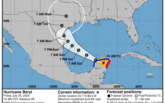
All eyes are on the gulf and southeast Texas as the strongest hurricane on record to hit the Windward Islands of the Caribbean so early in the season makes landfall in the Yucatán Peninsula Friday morning.
Hurricane Beryl carved a life-threatening path of destruction across Jamaica with sustained winds of up to 140 miles an hour. The full assessment of the impact is still considered days away due to loss of communication and the difficulty of reaching many parts of the islands affected.
This morning, a hurricane warning is in effect for much of the eastern coast of Mexico’s Yucatán Peninsula. Tropical storm warnings are in effect for the northern and western coasts of that peninsula, too.
But the intensity of the storm is also slowing a bit at last check, vacillating between a category 3 and a category 2 storm. Right now, many meteorologists are busy calculating whether and to what extent this storm might take a more direct westward track towards central Mexico, or move northwest toward Brownsville, Corpus Christi and the Texas Gulf Coast.
Matt Lanza, a meteorologist with Space City Weather in Houston, said now that the storm has made landfall in Mexico, it has lost its heat source — the water.
“It’s over land and should steadily weaken over the next few hours and is expected to come across the peninsula and emerge on the other side as a tropical storm back over the Gulf,” Lanza said. “So it’s going to have to do a little bit of rebuilding from there. But right now, the main impacts are in Mexico, and we’ll be watching to see how this evolves over the next day or two.”
Lanza said that if Beryl turns into a tropical storm, it should hopefully be a little less organized – which means it will do less damage.
“But it will probably still have at least a little bit of a core intact to rebuild from. And while the gulf is warm, it’s not the rocket fuel of the Caribbean, fortunately,” he said.
“But it is still pretty warm for this time of year. And so that’s going to allow Beryl to steadily strengthen as it approaches the northeast Mexico or southwest Texas coast as we go into Sunday, and probably come ashore probably as a hurricane again. Not a major hurricane, but still a hurricane nonetheless.”
Early impacts to the Coastal Bend area of Texas should start Sunday into Monday, he said.
“If I were living in the lower Texas coast or the middle Texas coast, I would be preparing as if a hurricane were coming right now and expect at least a category 1, possibly a category 2. You always want to over-prepare a little bit. Expect a category above what’s forecast, just in case,” he said.
“We’ve seen so many instances of storms rapidly intensifying over the last few years and not being well forecast. So, it’s important for folks to just budget a little bit more, in case the storm comes in stronger.”
Since we don’t know exactly where the storm’s path will take it, Lanza recommends people keep an eye on the weather forecast.
“There will be gusty winds, I think, inland from the coast. But they will not be hurricane-force winds. The hurricane-force winds only extend out about 30 miles (from the coast). So this is a relatively compact storm from that point of view,” he said.
“But the rain is going to be very heavy. And as is the case in Texas, we always have to watch for the flooding. And we’ll be expecting some heavy rainfall going into Monday and Tuesday of next week.”
For those on the coast, the winds are the biggest concern, but for those living inland, the rain will be the larger factor, Lanza said.
“These things are so complex. For coastal folks, it’s the wind. For inland folks, it’s the rain. And we just want to watch this to make sure that it continues on a steady track to the north,” Lanza said.
“It is expected to slow down a bit. And that’s why we’re a little concerned about maybe some higher rainfall totals as this comes inland. But we’ll just keep watching and hoping for the best over the next couple days.”