- Trump approves federal assistance amid Arkansas flooding
- Weather Impact Alert: Tornado Watch issued for much of Southeast Texas until 9 p.m.
- Colorado State University predicts above-average 2025 Atlantic Hurricane Season
- South and Midwest face potentially catastrophic rains and floods while reeling from tornadoes
- Deadly 2024 hurricanes prompt WMO to retire three names
🚨Live updates🚨Path takes Tropical Storm Debby straight through NC, extremely rare flood risk issued for Thursday
Tropical Storm Debby is dropping rain in North Carolina as it moves along the Georgia-South Carolina coastline. The newest path takes Debby straight through North Carolina, according to the National Hurricane Center.
Links to know: WRAL interactive hurricane tracker | Download the WRAL News app for alerts | WRAL images illustrate timing of Debby | Closings and delays
The Triangle will see periods of heavy rain and flooding through Friday. Gov. Roy Cooper declared a State of Emergency.
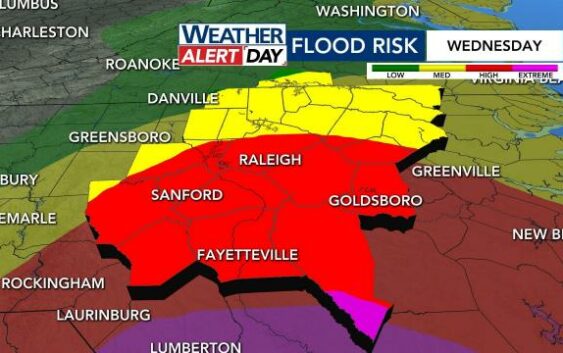
- Extreme flood risk: A rare extreme flood risk is in effect Thursday for the Triangle, the Triad and much of central North Carolina, according to NOAA’s Weather Prediction Center. Extreme risks are responsible for 39% of flood-related deaths and 83% of flood-related damages.
- Alerts:
- Storm track: The latest track shows Debby moving across North Carolina Thursday night.
- Impact: Central North Carolina could see 4 to 10 inches of rain, with higher amounts and flooding along and east of Interstate 95 and at the coast.
- Tornado potential: Multiple tornadoes were confirmed in South Carolina as Debby moved through. There’s the threat for that to happen east of Raleigh Thursday.

What to expect where you live
Triangle: The latest path shows Debby’s center could move through North Carolina Thursday night. The Triangle will see periods of rain and flooding Tuesday through Friday. The Triangle is under an extreme risk for flooding on Thursday.
NC coast/eastern counties: Debby is already prompting tornado watches and warnings at Wrightsville Beach and surrounding areas. Tropical Storm Debby is approaching the North Carolina coast, prompting tropical storm and storm surge watches for parts of the state.
Fayetteville/southeastern counties: Tropical Storm Debby is expected to dump around 9 inches of rain in counties south of the Triangle. River flooding is a concern, with major flooding already forecast for the Lumber River in Lumberton.
South Carolina: Some strengthening is forecast Wednesday and Thursday as Debby drifts offshore, before it moves inland Thursday over South Carolina. Flash flood warnings, Tornado warnings and curfews have been issued for parts of South Carolina.
Timing out the impacts of Tropical Storm Debby

WEDNESDAY: Rain gradually spreads southeast to northwest. Wednesday will become a worse day for Fayetteville as opposed to Hillsborough. The flood threat increases later in the day into the night for the Sandhills and the Triangle. There is a tornado threat to the south and east of us. The wind isn’t that big of an issue.
THURSDAY: This is the worst day for us. The center of Debby will be just to our south. We’ll be on the northern/northeastern end. An extreme risk for flooding has been posted by NOAA’s Weather Prediction Center – a first for our area since Dorian in 2019. Wind gusts could reach 30 mph or higher. Any other day, we wouldn’t care. However, with the ground being so saturated and wet, we could see some outages from wind damage and downed trees.

There’s a chance for brief tornadoes mainly east of Raleigh starting late Thursday morning and lasting off-and-on throughout the day.
FRIDAY: The morning will be the wettest time of day with localized flooding continuing. Wind gusts will continue, too. The threat for any brief spin-ups looks farther east. Debby finally starts pushing northward by the evening and overnight. Some wind will come in on the back end.

Rivers will continue to rise even after the rain has left. This is especially the case east of the Triangle, as water starts flowing out toward the Atlantic.
Please continue to stay weather aware. This storm is exhausting, because it’s not going to be moving much. That said, WRAL News is equipped to keep you updated across all platforms. Be prepared, not scared.
WRAL interactive hurricane tracker | Download the WRAL News app for alerts | Timing of Debby
Newest path shows Debby moving across NC Thursday, Friday
Debby remains a slow-moving tropical storm, moving east at 5 mph with maximum sustained winds of 45 mph. The Triangle is already seeing rain from Debby, and others areas are seeing storms and stronger winds.
The slow-moving storm is expected to dump heavy rain across central and eastern North Carolina. The flood risk is the highest it’s been in nearly five years for our area, WRAL meteorologist Kat Campbell said.
Projections show Debby moving through North Carolina a bit faster than anticipated, according to Campbell. The greatest impact to our state comes on Thursday, and Debby’s center could move through North Carolina as a tropical storm Thursday night.
“It’s something we’re taking very seriously,” Gardner said.
The tropical storm will be especially dangerous since it’s slow moving and can drop a lot of rain over a longer period of time. This could lead to dangerous flooding.
North Carolina State Fire Marshal Brian Taylor said Debby could rival the devastating impacts of Hurricane Florence.
“All indications are pointing to this storm being similar in magnitude to Hurricane Florence,” Taylor said. “Residents should be prepared for widespread power outages and severe flooding across the central and eastern regions of North Carolina.”

Much of North Carolina is expected to experience heavy rainfall through Friday. A flood watch is in effect for our area and the coast until 9 p.m. Friday.

A storm surge watch and a tropical storm warning are in effect for parts of the N.C. coast, which means that tropical storm conditions and serious flooding are expected.

The worst of the storm for our area comes Wednesday through Friday, which is why WRAL meteorologists issued WRAL Weather Alert Days. The main threat is flooding, but wind gusts could bring down trees and cause power outages.
It will be windy throughout the day on Thursday, with some areas expected to experience gusts of 45 mph or higher.

WRAL meteorologists estimate between 5 to 10 inches for WRAL’s coverage area, mainly between Wednesday and Friday. Counties to the northwest will see less rain, and counties to the southeast will see more, especially along the coast and in South Carolina.
Estimated rain totals from Debby include:
- Wilmington: 10-15 inches
- Fayetteville: 7-10 inches
- Raleigh: 5-7 inches
- Northern counties: 2-5 inches
Highs will be cooler, in the low 80s, throughout Debby’s impact.
The latest: National Hurricane Center tracks Debby
Thursday
7 a.m.: Water is ankle-deep on the flooded roads in Ocean Isle Beach.
5 a.m.: The newest path takes Debby straight through North Carolina on Thursday and Friday.
Wednesday
11 p.m.: Tropical Storm Debby continues to slowly move toward North Carolina.
8 p.m.: The center of Debby is now offshore from the Georgia and South Carolina coasts.
5 p.m.: Voluntary evacuations are now in place at Ocean Isle Beach, where a State of Emergency has been declared. Debby is moving slowly near the Georgia and South Carolina coasts.
3:20 p.m.: Fayetteville declares a State of Emergency.
11 a.m.: New path for Debby takes it through North Carolina as a tropical storm Friday.
5 a.m.: Debby is still a tropical storm, moving pain-stakingly slow at 5 mph. It will move through North Carolina Thursday night.
Tuesday
11 p.m.: While the coast of Georgia was removed from a tropical storm warning, several North Carolina cities are under a tropical storm warning. The storm is moving east at 5 mph with maximum sustained winds of 40 mph.
8 p.m.: Debbie continues moving slowly towards North Carolina. It continues moving at 3 mph but has shifted north, with maximum sustained winds of 40 mph. While it’s moving north, it is still off the coast of Georgia and South Carolina.
5 p.m.: Debbie has slowed down again, now moving at east-northeast with maximum sustained winds of 40 mph. and is 282 miles away from Raleigh.
2 p.m.: A flood advisory is in effect for Chatham, Durham, Orange and Wake counties until 3:30 p.m. as Debby’s outer rain bands impact the Triangle. The National Hurricane Center said Debby remains a tropical storm with maximum sustained winds of 40 mph. It is currently 291 miles south-southwest of Raleigh.
11:30 a.m.: Johnston Community College will be closed beginning Wednesday through 8 a.m. on Monday due to the severe weather threat. New student orientation on Thursday was also canceled.
11 a.m.: The latest path takes Debby through North Carolina as a tropical storm on Friday. Debby remains a tropical storm with 40 mph winds and is moving northeast at 6 mph.

8 a.m.: Tropical Storm Debby has 45 mph winds and is expected to move offshore of the Georgia coast later on Tuesday. Flooding will be a major threat over portions of Georgia, South Carolina and North Carolina over the next few days. The storm is moving northeast slowly at 6 mph.
At Myrtle Beach, double red flags were posted, which means no one is allowed in the water.
5 a.m.: The newest path takes Debby straight through North Carolina, the National Hurricane Center said.
Monday
11 p.m.: Governor Roy Cooper declared a state of emergency in anticipation of Tropical Storm Debby’s impact. Debby has weakened slightly, with sustained winds now at 45 mph, but remains a slow-moving storm, creeping northeast at 7 mph.
5 p.m.: Parts of the North Carolina coast are under a tropical storm watch and a storm surge watch as Tropical Storm Debby moves northeast. At 5 p.m., the storm had 50 mph winds and was moving northeast near the Florida-Georgia border.
2 p.m.: The 2 p.m. advisory from the National Hurricane Center shows Tropical Storm Debby moving over northern Florida with maximum winds at 65 mph.
11 a.m.: Debby remains a tropical storm over Florida with 70 mph winds, moving toward Georgia.
9 a.m.: Debby was downgraded to a tropical storm as of the 9 a.m. advisory from the National Hurricane Center. For our local weather, whether this is a depression or storm doesn’t matter. This will be a big rain-maker.
7 a.m.: The National Hurricane Center confirms that Debby made landfall Monday morning as a Category 1 hurricane. It happened around 7 a.m. near Steinhatchee, Florida.
How to prepare for a tropical storm or hurricane
From late spring through the fall, there is always the chance that a hurricane will form in the Atlantic Ocean and impact North Carolina. While rough surf and overwash is a danger along the coast, hurricanes can bring torrential downpours, inland flooding, downed trees and even tornadoes to the Triangle.
Property owners should consider flood insurance and make sure to keep up home maintenance so that roofs, shingle and outdoor furniture are secure when high winds blow.
Make an emergency plan and communicate with each family member so that you can make a choice – to stay or go.
No matter where you live, you could lose power. It always pays to be prepared for a storm that can knock out power with a survival kit that includes non-perishable food, cash and plenty of clean, bottled water.