- Carolina Hurricanes playoff tickets go on sale next week
- Weather Impact Alert: Cold front could trigger severe weather in Houston area this weekend | See timeline
- Violent storms cut through the South and Midwest, spawning tornadoes and killing 3
- Above-normal active 2025 hurricane season predicted by Colorado State University
- Cold front could trigger severe weather in Houston area this weekend | Timeline for potential storms
NC river flooding: Which rivers flood most often, why it happens
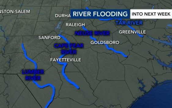
WRAL meteorologists are closely watching the levels of several North Carolina rivers as Debby inches closes to North Carolina.
North Carolina’s interactive Flood Inundation Mapping and Alert Network (FIMAN) map uses more than 500 gauges to show what rivers are close to moderate and major flood stage. There are several rivers east of the Triangle that WRAL meteorologists will be watching closely in the coming days.
The latest river forecasts from National Weather Service are listed below. These forecasts can change depending on how much rain actually falls. Even moderate flood stage can cause minor flooding issues, according to WRAL meteorologist Elizabeth Gardner.
- Neuse River at Clayton: Expected to reach moderate flood stage by 8 p.m. Friday.
- Potential impact: Greenway flooding
- Neuse River at Smithfield: Expected to reach moderate flood stage by 8 a.m. Saturday
- Potential impact: Town Park and river flooding
- Neuse River at Goldsboro: Expected to reach moderate flood stage by 2 p.m. Sunday
- Potential impact: Flooding of Seymour-Johnson Air Force Base
- Cape Fear River at Fayetteville: Expected to reach moderate flood stage by 2 p.m. Saturday
- Potential impact: Overflow of the left bank
- Lumber River at Lumberton: Expected to reach major flood stage by 8 p.m. Thursday
- Potential impact: Extensive flooding along the river. Over 50 dwellings inundated or isolated due to the flood waters. Several roads closed, especially in the Pines area and Cox Pond area. Carthage Road may be completely covered with water.


Why do rivers flood after storms?
Flooding doesn’t just occur along North Carolina’s coast. Rivers flood too, and the worst flooding often occurs after a storm.
“As rain falls, it goes into the soil and then goes into the river,” WRAL meteorologist Chris Michaels explained. “This is why you’ll often see river levels rise to their highest levels days after the last rain drop falls.”
Rivers flow eastward and downstream into the Atlantic Ocean, so rivers farther east face a higher flood threat than those farther west. However, according to Michaels, that may change if rain totals exceed expectations in areas like the Triad.
Get alerts when rivers flood with NC FIMAN
North Carolina’s Flood Inundation Mapping and Alert Network (FIMAN) map shows flooding forecasts from more than 500 gauges across the state so people can see if their area will be flooded during a particular storm.
People can click the alarm icon in the top right corner of the map to be notified if a river is flooding in their area.
The map also shows historical rainfall events that caused rivers to flood.
NC river flooding: A history
In September 2018, Hurricane Florence dumped 8 trillion gallons of water across North Carolina. It happened just two years after Hurricane Matthew brought devastating rainfall to the same area.
Both Matthew and Florence brought record flooding to North Carolina’s rivers. During Matthew, the Lumber River in Lumberton crested at 28 feet, the highest it ever had. That record was shattered when Florence crested the river just two years later at 29 feet and covered parts of Interstate 95.
The Neuse River in Goldsboro also crested to record levels during Matthew, rising to 29.74 feet. Two years later, during Florence, it reached the third highest crest on record at 27.6 feet.
The Cape Fear River in Fayetteville also reached astonishing levels, topping out at the sixth highest crest on record during Matthew at 58.94 feet. Two years later, Florence helped it record the fifth highest crest on record, at 61.58 feet.
The rivers remained above flood stage for weeks after the storms passed.