- Western NC wildfire risk will 'get worse, not better' Ag Commissioner says, pressing lawmakers for help
- Watering trees is a must to protect them from severe weather and drought
- At least 4 dead, hundreds rescued after deadly floods ravage South Texas
- Today on Texas Standard: Deadly floods swamp South Texas, shatter records
- North Carolina radio station was a critical lifeline after Hurricane Helene. Then it became the voice of recovery.
Forecast: Rain chances ramp up Labor Day Weekend, minor flooding possible
Here are the latest updates from the KVUE Weather Team.
Shane Hinton (KVUE), Jordan Darensbourg, Hunter Williams, Grace Thornton
11:46 AM CST March 6, 2019
7:59 AM CDT September 1, 2024
AUSTIN, Texas — Happy Meteorological Fall everyone!
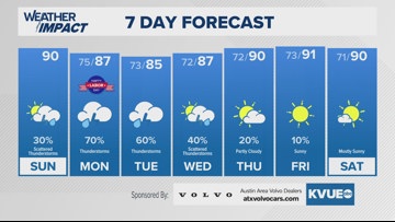
Central Texas’s forecast remains largely unchanged for the next 48 hours. Moisture trends will continue to move upward, while temperatures drop downward. I guess this would be our chance at “fall-like” temperatures for a while, as afternoon highs sink into the mid-80s for Monday and Tuesday due to thick clouds and higher rain chances.
Sunday starts dry and partly cloudy, with moisture moving in for the late afternoon and evening. Scattered showers and a few isolated storms may bring minor flooding to a few areas, but for the most part, the pattern will be generally hit or miss, so no need to cancel any outdoor grilling plans.
However, If you have mainly outdoor plans for Labor Day, make sure you have a place to duck away from any downpours that may pass over. Overall Rain chances increase to a 60-70% for Monday evening. The Texas Hill Country and areas west of I-35 have a level 2 out of 4 “slight” risk for flash flooding due to the heavy rains within storms Monday.
Be sure to check in on the radar from time to time. We return to 20-30% chances for rain at the end of next week.
SUNDAY:
Mostly cloudy. 20% chance for passing showers. Northeast wind at 5 to 10 mph.
HIGH: 90
SUNDAY NIGHT:
40% chance of showers or storm until 8 p.m. Northeast wind at 5 to 10 mph.
LOW: 76
SEVEN-DAY FORECAST:

Check out the live radar for what you can expect the rest of the day and into the workweek.