- McDowell County wildfire spreads to 500 acres, evacuation orders in place
- Evacuations in Caldwell County due to wildfire
- Northwest Houston 'ghost neighborhood' caused by repeated flooding to become latest detention basin
- NHL playoffs: Hurricanes open playoffs Easter Sunday afternoon vs. Devils
- 2 wildfires spreading in rugged terrain in western North Carolina
Tropical Storm Francine to bring lots of rain to the Texas Coast before it hits Louisiana
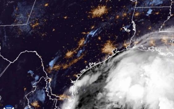
Tropical Storm Francine is brewing in the Gulf of Mexico and is expected to become a hurricane as it moves up the coast.
Matt Lanza, a forecast meteorologist and managing editor of Space City Weather in Houston, said most of the impact of this storm is expected to hit Louisiana.
“Francine is sitting off the coast of Mexico and it is expected to continue off to the north and northeast. And that should put it on a track probably towards central Louisiana, somewhere in that area for a landfall sometime tomorrow,” Lanza said. “[It will likely] brush the Texas coast with some fringe impacts for the most part between Sabine Pass and down through Corpus Christi, as well as some heavy rain perhaps in the Brownsville area out towards South Padre Island.”
Lanza said that given the forecasted path of the storm, most Texans should be okay to weather it with their typical protective measures.
“We’re expecting a storm surge of about one to three feet on most of the Texas coast,” he said. “For the most part, this shouldn’t be anything worse than what we saw back during Tropical Storm Alberto, the first storm of the season, which was back in June before Beryl. So most areas will manage this okay with just some minor flooding in the usual trouble spots.
“I really think the most interesting area in terms of watching is actually the Lower Rio Grande Valley, Brownsville through about Port Isabel. We’re going to see anywhere from about three to six inches of rain. That could cause some flash flooding in those areas.”
» MORE: How this year’s hurricane season has shaped up for energy markets
Compared to Hurricane Beryl, however, Lanza said this storm should be just a blip on Texas’ radar.
“This is nothing like Beryl, thankfully, particularly for folks in Houston that have been watching this with very bated breath. This is fortunately going to turn to the northeast and pass away from us rather than then hit us directly. So that’s good,” he said. “And this is also a storm that’s sort of in its nascent development phases. So it’s really not there yet.
“Beryl had itself pretty much together when it got in the Gulf, so it didn’t take a whole lot for things to get going before it got revved up and hit the Texas coast.”
Francine is expected to make landfall tomorrow, according to Lanza, which means Texans in the path of the storm need to buckle up for rain today.
“We’re going to see Francine make landfall in Louisiana tomorrow afternoon. Today will probably be the worst day for South Texas — so from Corpus Christi through Brownsville, that’ll be when you see most of your rain. That should taper off going into tonight and tomorrow,” Lanza said. “For the Houston area up through Beaumont, Port Arthur, Sabine Pass, those areas will see some periods of rain perhaps going into tonight and tomorrow morning and then it should shut off tomorrow afternoon.
“The gusty winds will probably occur sometime tomorrow morning on the Texas coast or at least the upper Texas coast. So that’s when Galveston could see wind gusts of 40 miles an hour or something like that.”
» GET MORE NEWS FROM AROUND THE STATE: Sign up for Texas Standard’s weekly newsletters
Lanza said this hurricane season has been a strange one — quieter than originally anticipated but still with months to go before it officially ends on Nov. 30.
“There’s a couple of things I think that are noteworthy with Francine in particular – it just proves again that the Gulf is capable of sustaining a tropical storm or a hurricane almost no matter what,” he said. “It just takes the wrong combination of ingredients that come together and you can generate something in the Gulf, even in an overall hostile environment for tropical storms and hurricanes like we’ve seen across most of the Atlantic Basin over the last month and a half.”