- Report: Coastal flooding could threaten 1.4 million homes by midcentury
- Caught on camera | Tornado touches down in Missouri
- Carolina Hurricanes playoff tickets go on sale next week
- Storms kill 6 in the South and Midwest as forecasters warn of catastrophic rains, floods this week
- Weather Impact Alert: Cold front could trigger severe weather in Houston area this weekend | See timeline
Latest: Life-threatening flooding at NC coast, heavy rain moves into Wake County from Potential Tropical Cyclone #8
On Monday, Potential Tropical Cyclone #8 is bringing heavy rain, strong winds and a threat for tornadoes, flooding and power outages to North Carolina.
The biggest impacts from PTC #8 will be felt throughout Monday and into Tuesday. According to WRAL meteorologist Chris Michaels, PTC #8 could become Helene on Monday, but the impact to North Carolina will be the same even if the storm isn’t named. Flood watches and wind advisories are in effect for central N.C., and tropical storm warnings are in effect along the N.C. coast.
Helpful links: Sign up for WRAL weather alerts | Live DUALDoppler5000 | Wind speeds and wind gusts | Live cams across NC | WRAL interactive hurricane tracker
Live updates
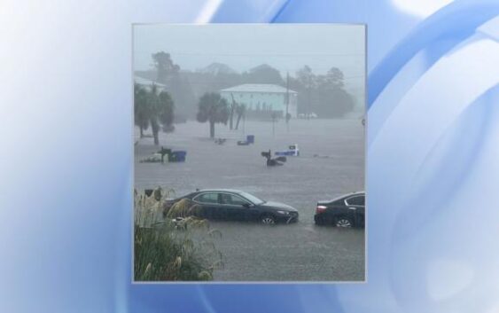
12 p.m.: The town of Carolina Beach posted photos of cars with tires half-covered by floodwaters and back porches partially underwater, writing:
“Life-threatening flash flooding is ongoing in Carolina Beach where volunteer rain gauges and radar are estimating over 15 inches of rain may have fallen.”
11:30 a.m.: As heavy rain falls in southern Wake County, tornado warnings are popping up closer to the coast, including in Duplin County. Areas along the coast have already seen flooding. The heaviest rain has been south of the Triangle, but bigger flooding impacts will come Monday afternoon.
11 a.m.: The 11 a.m. advisory from the National Hurricane Center shows PTC #8 right off the coast of the Carolinas with 50 mph winds. The storm will move onshore in South Carolina and track toward the North Carolina mountains.
Timing, impact of Potential Tropical Cyclone #8
Off-and-on heavy rain and wind gusts between 25 and 35 mph will be likely on Monday afternoon in the Triangle, and flooding, localized wind damage and power outages will all be possible.
")
Monday is a WRAL Weather Alert Day as a result of PTC #8, and there is a Level 1 (out of 5) risk for a tornado late Monday afternoon into the evening, mainly in areas south and east of the Triangle.
The National Hurricane Center (NHC) said on X that the system could cause flash flooding and minor river flooding across southeast North Carolina. Coastal flooding and high surf will also be possible along the N.C. coast, the NHC said.
Conditions will begin to improve Tuesday, when early morning rain and winds will be possible. Showers and storms will turn more isolated by Tuesday afternoon, according to Michaels.
Looking at the week ahead, the area of low pressure will weaken, but impacts will linger throughout the week.
“This means there will be the daily chance for scattered showers and storms each afternoon and evening Wednesday through Friday,” Michaels said. “Some dry air may arrive in time for the weekend.”
NC emergency crews on standby
State agencies are gearing up for potential storm impacts on Monday following the issuance of a WRAL Weather Alert Day.
Emergency Management teams are ready to mobilize from their facility, providing crews, equipment, and support to areas—especially along the coast—that may require additional assistance.
Just over a month ago, Tropical Storm Debby lashed the region with strong winds and heavy rains. More severe coastal weather is expected this week from Potential Tropical Cyclone #8.
Flooding is often the most dangerous part of a storm.
“Water is one of the most powerful forces on Earth. Even a small amount of rain or floodwater on a roadway can be devastating,” said Darshan Patel, Operations Manager for Wake County Emergency Management.
Patel said, with the ground already saturated from this week’s rain, flooding could easily occur in low-lying areas.
“We’re working closely with our partners to assess potential public safety concerns. If risks are identified, we’re ready to take proactive measures,” he said.
Crews are monitoring road conditions and power lines. Duke Energy is anticipating possible outages if strong coastal winds move inland and combine with heavy rainfall.
“It’s a constant challenge with Mother Nature,” said Jeff Brooks, a spokesperson for Duke Energy. “Soggy ground makes it even harder to prevent outages caused by falling trees, but we’re doing everything we can to minimize disruptions.”
Duke Energy is keeping its current teams on standby, prepared to deploy them to critical areas if needed.
Although summer is winding down, the peak of tropical storm season is just beginning.
“This system developed quickly off the coast and will bring nasty weather over the next few days. We might see more storms like this soon,” Brooks said.
For local safety updates, residents are encouraged to use ReadyWake, a mobile resource that provides notifications about potential hazards in their area.