- Report: Coastal flooding could threaten 1.4 million homes by midcentury
- Caught on camera | Tornado touches down in Missouri
- Carolina Hurricanes playoff tickets go on sale next week
- Storms kill 6 in the South and Midwest as forecasters warn of catastrophic rains, floods this week
- Weather Impact Alert: Cold front could trigger severe weather in Houston area this weekend | See timeline
Steady rain, potential flash flooding
Tropical impacts through Tuesday night.
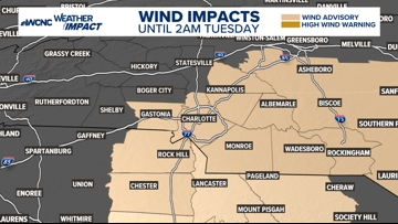
CHARLOTTE, N.C. —
Today
Weather Aware: Rain has moved in and will continue through the day. Expect mainly a light to moderate rainfall with the best chance for heavier rain, moves in throughout this evening. Winds will also increase through the day as Charlotte and areas east are under a wind advisory until 2 a.m..

Periods of rain with gusty winds ranging from 30-40 mph could lead to some downed and uprooted trees later this evening and overnight.
Tropical Impacts
A Potential Tropical Cyclone has developed off the North and South Carolina coastline. The system still needs to become more organized to get a name. If it does get a name the next name on the Atlantic hurricane list is Helene.
The coast will take the brunt of the system with stronger winds, increasing wave heights, beach erosion, and rip current risk. along with coastal flooding on some oceanfront properties.
Local Impacts
Rain: Prepare for rain as early as early afternoon. The onset of light showers is expected to become widespread followed by heavy rain. Some areas could experience flashing flooding due to excessive rainfall. Upwards of 3 inches is possible. By Wednesday, the system will lift north of us allowing some drier air to mix in and reduce rain chances.
Wind
Gusty winds are ongoing tonight ahead the system. Expect winds to increase to upwards of 20 to 35 mph by Monday evening. This could have an impact on trees and power lines. Be mindful of these impacts and use caution while driving if you encounter a down tree or power line especially at times when your visibility is reduced due to rain.
Tropical Update
Elsewhere, Tropical Storm Gordon formed Friday way out in the central Atlantic. It is still far away from impacting land of any kind but our team will monitor closely.
WCNC Charlotte’s Weather IQ YouTube channel gives detailed explainers from the WCNC Charlotte meteorologists to help you learn and understand weather, climate and science. Watch previous stories where you can raise your Weather IQ in the YouTube playlist below and subscribe to get updated when new videos are uploaded.
Stay connected to the WCNC Charlotte Weather Team:
Contact Brad Panovich at bpanovich@wcnc.com or follow him on Facebook, X and Instagram.
Contact Larry Sprinkle at lsprinkle@wcnc.com and follow him on Facebook, X and Instagram.
Contact Chris Mulcahy at cmulcahy@wcnc.com and follow him on Facebook, X, Instagram, and TikTok.
Contact Brittany Van Voorhees at bvanvoorhe@wcnc.com and follow her on Facebook, X and Instagram.
Contact KJ Jacobs at kjacobs3@wcnc.com and follow him on Facebook, X and Instagram.