- Report: Coastal flooding could threaten 1.4 million homes by midcentury
- Caught on camera | Tornado touches down in Missouri
- Carolina Hurricanes playoff tickets go on sale next week
- Storms kill 6 in the South and Midwest as forecasters warn of catastrophic rains, floods this week
- Weather Impact Alert: Cold front could trigger severe weather in Houston area this weekend | See timeline
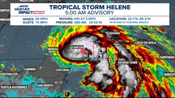
Tropical Storm Helene officially forms; Set to become major hurricane before landfall in Florida
Chief Brad Panovich and the WCNC Weather Impact Team explains the impacts set to come from Hurricane Helene.
CHARLOTTE, N.C. — Potential Tropical Cyclone No. 9 was upgraded to Tropical Storm Helene, as of the 11 a.m. advisory from the National Hurricane Center on Tuesday morning. This is the eighth named storm of the 2024 Atlantic Hurricane Season.
HYPERLOCAL IMPACTS: For continuing updates on Helene in the Carolinas, see updates from the WCNC Weather Impact Team
The maximum sustained winds are now within the tropical storm criteria, which range between 39 and 73 mph. Helene will continue to become more organized throughout Wednesday. The storm is forecast to rapidly intensify and is forecast to become a hurricane with winds of at least 74 mph.

“Regardless of strength, the impacts are going to be pretty devastating somewhere on the Gulf Coast,” Panovich said in a vlog, which was posted to the WCNC Charlotte Weather IQ YouTube channel.
Wednesday’s rapid intensification
Helene is forecast to rapidly intensify.
Rapid intensification is when a tropical system increases its maximum sustained winds by 35 mph or more within 24 hours.
Helene will have the opportunity to rapidly intensify because:
- There is a tremendous amount of warm, moist tropical air without any dry air or dust to impede development
- Limited wind shear will allow the hurricane to grow with ease
- Water temperatures are in the mid-to-upper 80s
Current estimates show Helene making landfall in either the Florida big bend area or in the Florida panhandle. At landfall, the storm will be a major hurricane with winds over 115 mph.
A “major hurricane” is defined by the National Hurricane Center as any storm Category 3 or higher. That means the storm would have at least sustained winds of 111 mph, according to the Saffir-Simpson hurricane wind scale.
RAISE YOUR WEATHER IQ: Inside the powerful winds of a hurricane
“So, I would not focus solely on the category. I would focus on the fact that this is going to be a significant storm and you need to pay attention to the system,” Panovich said. “Don’t look at the specifics we’re in the range where you need to focus on the bigger picture.”
As the storm moves further inland, impacts from excessive rain are expected to bring flooding to Georgia, South Carolina, North Carolina and Tennessee.
Florida landfall
For Florida, that big picture is huge storm surge, damaging winds and life-threatening flooding.
Even with an anticipated landfall closer to Tallahassee, Panovich advises impacts will be felt across Florida as heavy rains move across the entire state later on Wednesday.
Panovich posted on X, the social media site formally known as Twitter, on Tuesday to show how the impacts from Helene stretch beyond the official forecast cone, which is only intended to show the possible location of the storm’s center of circulation.
Carolina impacts

In the Carolinas, excessive rainfall is expected to bring flash flooding.
“We’ve got the high pressure off the East Coast. So everything’s gonna be funneling moisture into the Southeast,” Panovich explained. “So for the Carolinas in particular … huge flash flooding risk here”

The worst of the flooding could be in the mountains of western North Carolina.
“This is where we’re gonna have strong southeast winds interacting with the Blue Ridge Mountains,” Panovich said. “You’ll see some of these totals coming out of the mountains are approaching 10 inches or above.”
Around Charlotte, general rainfall amounts could amount to a couple of inches.
“So this is a significant flash flood risk to the mountains of North Carolina, upstate South Carolina and northeast Georgia,” Panovich said. “This is gonna have the potential to have a huge impact on parts of our area in the form of rain.”

The WCNC Weather Impact Team is tracking the storm and issuing forecast updates several times a day. Check back for the latest forecast path and expected impacts.