- CenterPoint Energy accelerates infrastructure improvements ahead of hurricane season
- Carolina Hurricanes playoff tickets go on sale Thursday
- Ask the Meteorologist: Why do tornadoes target Tornado Alley, Dixie Alley?
- Nonprofit closes distribution site that aided thousands after Hurricane Helene
- Trump approves federal assistance amid Arkansas flooding
Hurricane Helene: Life-threatening flood risk in NC mountains, tornado risk in Triangle

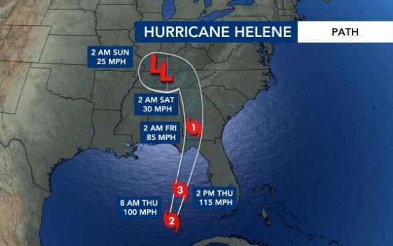
Hurricane Helene on Thursday strengthened to a Category 2 storm. As of the 11 a.m. advisory from the National Hurricane Center, Helene was moving northeast at 12 mph and is about 320 miles southwest of Tampa, Florida.
Helene is expected to make landfall by 8 p.m. on Thursday along the Florida panhandle as a strong Category 3 or 4 storm.
“As it moves over very warm ocean water, is likely to rapidly intensify to a Category 4 before it makes landfall,” WRAL meteorologist Elizabeth Gardner said. “It is likely to become Cat. 2, 3 and then 4 very quickly in the next few hours.”
The National Weather Service office in Tallahassee is forecasting storm surges of up to 20 feet and warned they could be particularly “catastrophic and unsurvivable.”
The National Weather Service (NWS) issued a tropical storm warning for parts of the North Carolina mountains and Charlotte. Many western North Carolina counties are under a tropical storm watch, and tornado warnings were popping up in the Charlotte area on Thursday morning.
North Carolina will feel the impacts of Helene on Thursday and Friday. The mountains will take the brunt of the storm, though conditions will also deteriorate in central N.C. and at the coast.
North Carolina Gov. Roy Cooper declared a State of Emergency on Wednesday ahead of the storm’s arrival.
Helene mountain impacts
In the North Carolina mountains, we could see wind gusts of 70 mph in higher elevations and 50 mph in lower elevations. This has the potential to cause widespread power outages and other wind-related damage.
The NWS said the western Carolinas could experience “catastrophic, life-threatening” flooding. A stationary front unaffiliated with Helene already dumped around six inches of rain in parts of the North Carolina mountains on Wednesday.
“We’re most concerned about the mountains of North Carolina,” Gardner said. “This is where the heaviest rain is going to be.”
Helene local impacts
Friday is when we’re expecting the worst impacts in North Carolina.
Impacts to central N.C. include 1 to 3 inches of rain, 20 to 30 mph wind gusts and isolated tornadoes. The best tornado threat will be Friday morning into the early afternoon, according to WRAL meteorologist Anthony Baglione.
“Our heaviest rain will come the first half of the day Friday,” said WRAL meteorologist Aimee Wilmoth. “By Friday night, then the heaviest rain moves to the north and west of us.”
Helene will then move quickly north through Georgia and west into Tennessee before breaking up.
“It’s likely to hold together as a category 1 hurricane as it moves through parts of Georgia, so that means a lot of wind damage there,” WRAL meteorologist Elizabeth Gardner said. “It moves into Tennessee and dissipates as we get into the weekend.”
The Triangle and surrounding areas are under a Level 1 risk for severe weather Thursday and a Level 2 risk for severe weather Friday.
Helene could be catastrophic for Florida
“A storm surge of 10-to-15 feet will be a big problem if this pans out,” said Wilmoth. “For reference, Hurricane Idalia brought a storm surge of 7-to-12 feet to the same area.”
The forecast track for Helene is very similar to that of Idalia, which slammed Keaton Beach, Florida, as a Cat. 3 hurricane in August 2023. Storm surge inundations of 7 to 12 feet along the coast were some of the highest values recorded since the 1993 Storm of the Century, accoding to the NWS.
“It’s been a rough couple of years for the Florida panhandle,” Wilmoth said. “Helene could make landfall close to where Idalia made landfall.”
Elsewhere in the Atlantic, Tropical Storm Issac formed. According to the National Hurricane Center, it’s not expected to impact the coast and will continue moving further east.
Make sure you’re staying up to date with the latest forecasts by downloading the WRAL News app.


