- 'A little emotional': Hurricanes equipment manager got seconds in goal, memory to last a lifetime
- WMO retires three hurricane names after devastating 2024 season
- Beryl removed from future hurricane naming lists
- Hurricane names Helene, Milton and Beryl are now retired
- Hurricane Helene's name retired after deadly 2024 impact on US
Weather Aware: Heavy rain, flooding and severe storms ahead of Helene's arrival
Multiple tornado warnings were issued Thursday as a line of storms swept over the Charlotte area before Hurricane Helene moves into the state.
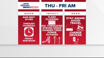
CHARLOTTE, N.C. — Multiple tornado warnings were issued in the Charlotte area Thursday morning ahead of Hurricane Helene as a line of storms brought heavy rain and gusty winds to the Carolinas. This was on top of a confirmed EF1 tornado in the Blowing Rock area around 6:38 p.m. Wednesday and various other tornado warnings over the course of 24 hours.
Helene is now a Category 3 major hurricane with sustained 125 mph winds. The storm will continue to gain strength as it approaches the Florida Big Bend, known as rapid intensification, and will lead to catastrophic wind, storm surge and flooding as Helene makes landfall Thursday night.
LIVE RADAR: Tracking Helene, impacts on the Carolinas

When will Charlotte see impacts?
Remember, this early rain and severe storm risk is not Helene moving inland. It’s tropical moisture pushing in from the south combined with a stalled front north and northwest of Charlotte.
More direct impacts from Helene begin across the Carolinas Thursday afternoon and evening, becoming more intense through the overnight hours. High winds and heavy rain will last through at least midday Friday before conditions slowly improve throughout the day.
Tropical storm watches and warnings are in place, including portions of our viewing area. A Tropical Storm Warning is in effect for Mecklenburg, Union, York, Chester, Gaston, Lincoln, Catawba, Cleveland, Burke, Caldwell and Avery counties. Impacted cities and towns include Banner Elk, Shelby, Lenoir, Morganton, Hickory, Newton, Gastonia, Charlotte, Rock Hill, Fort Mill, Chester, Lincolnton, Monroe, Huntersville, Matthews, and Cheraw.
Additionally, a Flood Watch is in place for Alexander, Catawba, Cleveland, Lincoln, Avery, Burke, Caldwell, Ashe, and Watauga counties.
What impacts to expect
Rainfall totals near ten inches in the mountains and foothills are possible with half of that across most of the Charlotte area. On top of rainfall, gusty winds of tropical-storm force (above 40 mph) are likely to cause trees to fall and scattered power outages across the region.
On top of the wind and rain, the Carolinas are expected to be in the right-front quadrant of Helene, often referred to as the “dirty side.” This will lead to a higher-than-average risk of quick spin-up tornadoes, especially Thursday night through Friday morning. Tropical tornadoes are often very weak but they can still produce impacts.
What you need to know to stay safe
In the event of a severe storm, stay Weather Aware by:
- Seeking shelters indoors away from lightning and gusty winds
- Having your weather radio on hand and your safe place picked out
- Pack essentials, including medications and pet supplies, in case you have to evacuate quickly
- Watching for flooded creeks and streams
- If you encounter a flooded roadway: turn around, don’t drown
- Monitoring radar for quick-moving thunderstorms that could disrupt outdoor plans