- 'A little emotional': Hurricanes equipment manager got seconds in goal, memory to last a lifetime
- WMO retires three hurricane names after devastating 2024 season
- Beryl removed from future hurricane naming lists
- Hurricane names Helene, Milton and Beryl are now retired
- Hurricane Helene's name retired after deadly 2024 impact on US
Weather Aware: Helene brings flash floods, power outages to the Carolinas
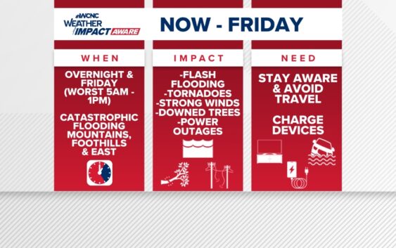
Helene was downgraded to a tropical storm at 5 a.m., but the impacts are still severe.
CHARLOTTE, N.C. — Hurricane Helene made landfall around 11:10 p.m. Thursday about 10 miles east of Perry, Florida, as a Category 4 major hurricane with sustained winds at 140 mph.
Helene was downgraded to a tropical storm at 5 a.m. Friday, but the impacts will remain significant for the Carolinas with heavy rain, damaging winds and life-threatening flooding in many areas.
A Tornado Watch is in place through 8 a.m. for portions of the Charlotte area. This includes Chesterfield, Lancaster, Chester, Anson, Cabarrus, Gaston, Union (NC), Richmond and Mecklenburg counties.
A Flash Flood Warning is in effect for Cabarrus, Mecklenburg and Union counties until 10 a.m. due to heavy rain.
LIVE RADAR: Tracking Helene, impacts on the Carolinas
How long will Charlotte see impacts?
Impacts from Helene become more intense throughout Friday morning. Expect a flash flooding risk, severe storms and high winds through at least midday Friday before conditions slowly improve throughout the day.
Tropical Storm Watches and warnings are in place, including most of our viewing area. A Tropical Storm Warning is in effect for Mecklenburg, Union, York, Chester, Gaston, Lincoln, Catawba, Cleveland, Burke, Caldwell and Avery counties. Impacted cities and towns include Banner Elk, Shelby, Lenoir, Morganton, Hickory, Newton, Gastonia, Charlotte, Rock Hill, Fort Mill, Chester, Lincolnton, Monroe, Huntersville, Matthews, and Cheraw.
A Flash Flood Warning is in effect for Cabarrus, Mecklenburg and Union counties. That warning is in effect until 10 a.m. Friday.
What impacts to expect
Rainfall totals over a foot are likely across portions of the mountains and foothills. For the Charlotte metro, many areas have already received three to four inches of rain, so half a foot is very possible when all is said and done. On top of rainfall and flooding impacts, wind gusts of tropical-storm force (above 40 mph) are likely to cause trees to fall and scattered power outages across the region.
On top of the wind and rain, the Carolinas are expected to be in the right-front quadrant of Helene, often referred to as the “dirty side.” This will lead to a higher-than-average risk of quick spin-up tornadoes, especially overnight through Friday morning. Tropical tornadoes are often very weak but they can still produce impacts.
In the hours ahead of Helene’s landfall, county and city governments urged residents to either voluntarily evacuate or find shelter in lakeside and riverfront communities in both Gaston and Mecklenburg counties. Gaston County officials opened a shelter for people looking to avoid flooding.
What you need to know to stay safe
In the event of a severe storm, stay Weather Aware by:
- Seeking shelters indoors away from lightning and gusty winds
- Having your weather radio on hand and your safe place picked out
- Pack essentials, including medications and pet supplies, in case you have to evacuate quickly
- Watching for flooded creeks and streams
- If you encounter a flooded roadway: turn around, don’t drown
- Monitoring radar for quick-moving thunderstorms that could disrupt outdoor plans
Late Thursday night, the Red Cross confirmed it had opened multiple shelters across the western North Carolina region, including one shelter in Charlotte. Anyone who needs assistance can visit the Tuckaseegee Recreation Center, located at 4820 Tuckaseegee Road.