- Austin adopts new map that greatly expands area at risk of wildfire
- CenterPoint Energy accelerates infrastructure improvements ahead of hurricane season
- Carolina Hurricanes playoff tickets go on sale Thursday
- Ask the Meteorologist: Why do tornadoes target Tornado Alley, Dixie Alley?
- Nonprofit closes distribution site that aided thousands after Hurricane Helene
Weather Aware: Helene downgraded to tropical storm, worst impacts to come for the Carolinas
Multiple tornado warnings were issued Thursday as a line of storms swept over the Charlotte area before Helene moves into the state.
CHARLOTTE, N.C. — Helene made landfall around 11:10 p.m. about 10 miles east of Perry, Florida, as a Category 4 major hurricane (winds 140 mph). It’ll continue to batter the Big Bend and eventually the southeastern United States.
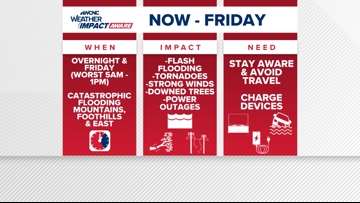
Helene was downgraded to a tropical storm at 5 a.m. Friday but the impacts will remain the same for the Carolinas with heavy rain, gusty winds and life-threatening flooding expected in many areas.
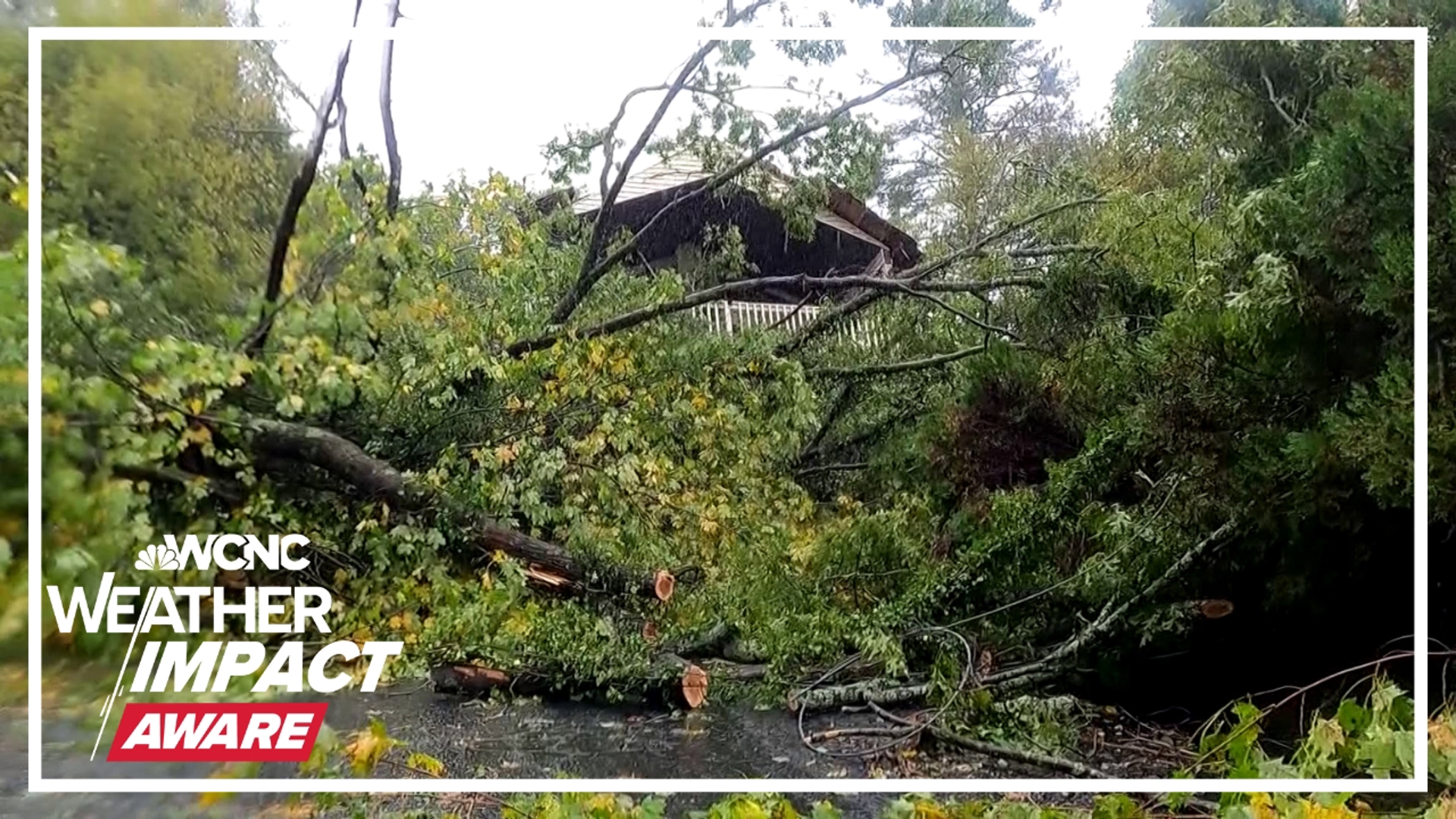
Multiple tornado warnings were issued in the Charlotte area Thursday morning ahead of Helene as a line of storms brought heavy rain and gusty winds to the Carolinas. This was on top of a confirmed EF1 tornado in the Blowing Rock area around 6:38 p.m. Wednesday and various other tornado warnings over the course of 24 hours.
A Tornado Watch is in place through 8 a.m. for portions of the Charlotte area. This includes Chesterfield, Lancaster, Chester, Anson, Cabarrus, Gaston, Union (NC), Richmond and Mecklenburg counties.
LIVE RADAR: Tracking Helene, impacts on the Carolinas

When will Charlotte see impacts?
Impacts from a stalled front and eventually Helene become more intense throughout Friday morning. Expect a flash flooding risk, severe storms and high winds through at least midday Friday before conditions slowly improve throughout the day.
Tropical storm watches and warnings are in place, including most of our viewing area. A Tropical Storm Warning is in effect for Mecklenburg, Union, York, Chester, Gaston, Lincoln, Catawba, Cleveland, Burke, Caldwell and Avery counties. Impacted cities and towns include Banner Elk, Shelby, Lenoir, Morganton, Hickory, Newton, Gastonia, Charlotte, Rock Hill, Fort Mill, Chester, Lincolnton, Monroe, Huntersville, Matthews, and Cheraw.
Additionally, a Flood Watch is in place for Alexander, Catawba, Cleveland, Lincoln, Avery, Burke, Caldwell, Ashe, and Watauga counties.
What impacts to expect
Rainfall totals over a foot are likely across portions of the mountains and foothills. For the Charlotte metro, many areas have already received three to four inches of rain, so half a foot is very possible when all is said and done. On top of rainfall and flooding impacts, wind gusts of tropical-storm force (above 40 mph) are likely to cause trees to fall and scattered power outages across the region.
On top of the wind and rain, the Carolinas are expected to be in the right-front quadrant of Helene, often referred to as the “dirty side.” This will lead to a higher-than-average risk of quick spin-up tornadoes, especially overnight through Friday morning. Tropical tornadoes are often very weak but they can still produce impacts.
More Videos
In the hours ahead of Helene’s landfall, county and city governments urged residents to either voluntarily evacuate or find shelter in lakeside and riverfront communities in both Gaston and Mecklenburg counties. Gaston County officials opened a shelter for people looking to avoid flooding.
“The river comes up a lot,” said Colby Cossette, who works at the Floyd & Blackie’s restaurant in Cramerton. “You’ll start to see trees go up – not up and down – but just down the river. In fact, we just saw one earlier as well. Hopefully that doesn’t continue to be bad, hopefully no powerlines or anything like that.”
Bobby Graham, a division chief with Charlotte Fire, said they had concerns for residents in western Mecklenburg County.
“Residents particularly around Mountain Island Lake,” he said, “and along Lake Norman, (Lake) Wylie and the Catawba River should prepare now, because we are going to have to issue volunteer evacuation orders.”
Those orders did eventually happen. Mountain Island Lake is normally 96 feet in elevation with the maximum at 100 feet. But rainfall Thursday night put lake levels at more than 101 feet as of 10 p.m. with expectations for levels to exceed 110 feet by Friday afternoon — the highest level it has ever reached.
What you need to know to stay safe
In the event of a severe storm, stay Weather Aware by:
- Seeking shelters indoors away from lightning and gusty winds
- Having your weather radio on hand and your safe place picked out
- Pack essentials, including medications and pet supplies, in case you have to evacuate quickly
- Watching for flooded creeks and streams
- If you encounter a flooded roadway: turn around, don’t drown
- Monitoring radar for quick-moving thunderstorms that could disrupt outdoor plans
Late Thursday night, the Red Cross confirmed it had opened multiple shelters across the western North Carolina region, including one shelter in Charlotte. Anyone who needs assistance can visit the Tuckaseegee Recreation Center, located at 4820 Tuckaseegee Road.