- Impact Plastics not responsible for workers killed in Helene flooding, TOSHA says
- 'A little emotional': Hurricanes equipment manager got seconds in goal, memory to last a lifetime
- WMO retires three hurricane names after devastating 2024 season
- Beryl removed from future hurricane naming lists
- Hurricane names Helene, Milton and Beryl are now retired
Hurricane Milton's rapid intensification linked to climate change, scientists say
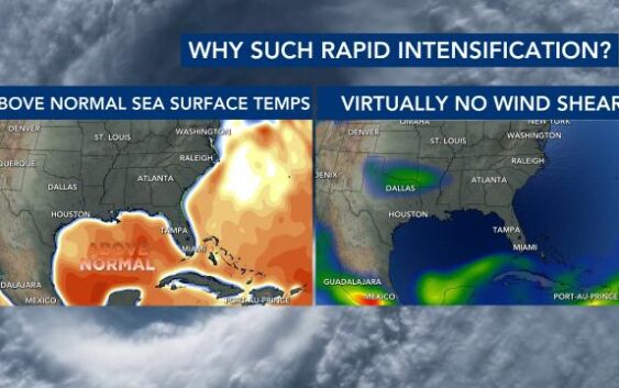
Hurricane Milton has intensified to a Category 5 storm with sustained winds of 175 mph as it moves through the southwestern Gulf of Mexico. The storm’s rapid intensification highlights how climate change is driving stronger, faster-developing hurricanes, fueled by rising sea surface temperatures.
Climate Central reports that Milton experienced “extreme rapid intensification,” defined as an increase of 58 mph or more within 24 hours. Milton far surpassed this, with winds increasing by 92 mph in that time frame. Among Category 4 and larger hurricanes since 2022, Milton reached Category 4 status the fastest.

From Sunday at 11 a.m. Monday at 11 a.m., Milton went from 65 mph to 150 mph. By 2 p.m. on Monday, Milton had maximum sustained winds of 175 mph.
“Climate change clearly warmed the Gulf waters that fueled Milton’s development, likely supercharging its rapid intensification and making this hurricane much more dangerous,” said Dr. Daniel Gilford, a meteorologist at Climate Central. “Fossil fuel pollution is amplifying this threat.”
Sea surface temperatures where Milton developed are at record highs. Climate Central’s analysis indicates that these elevated temperatures were made up to 800 times more likely due to climate change over the past two weeks. Future analyses could reveal an even stronger influence of warming.
Dr. Kevin Reed of Stony Brook University noted that warmer Gulf temperatures give storms like Milton the energy to intensify rapidly. “As sea surface temperatures approach 80 degrees Fahrenheit or higher, it increases the chance of rapid intensification,” he said. “The rise in Category 4 and 5 storms is a clear sign of climate change.”
Climate Central continues to use computer models to track how human-induced climate change fuels extreme weather, despite disruptions in data collection due to Hurricane Helene’s impact on NOAA’s National Centers for Environmental Information in Asheville, N.C.
“It’s definitely slowed down our ability to take data in and it’s slowed down and turned off some of our ability to share it,” said Deke Arndt, Director of the National Centers for Environmental Information. “This where a lot of the world’s weather, climate, ocean and coastal observations go live their second career as data sets that inform strategic decisions around the country and around the economy.”
Milton is expected to make landfall on Florida’s Gulf Coast late Wednesday. With Gulf temperatures up to 4 degrees higher than average, the storm’s rapid intensification is a stark warning of the increasing threat posed by a warming planet.
Warmer ocean temperatures not only strengthen winds but also increase the atmosphere’s moisture capacity, leading to heavier rainfall and flooding. “Hurricanes are becoming rainier and more intense due to climate change, with impacts reaching far inland,” Reed said.
As the planet continues to warm, scientists warn hurricanes will grow stronger, putting millions more at risk.