- Seven months after Hurricane Helene, Chimney Rock rebuilds with resilience
- Wildfire in New Jersey Pine Barrens expected to grow before it’s contained, officials say
- Storm damage forces recovery efforts in Lancaster, Chester counties
- Evacuation orders lifted as fast-moving New Jersey wildfire burns
- Heartbreak for NC resident as wildfire reduces lifetime home to ashes
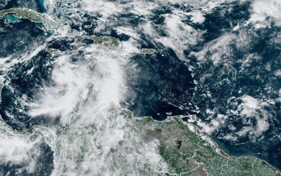
Storm in the Caribbean is on a track to likely hit Cuba as a hurricane

SAN JUAN, Puerto Rico (AP) — A new tropical storm was expected to form Monday in the Caribbean and bring heavy rain to Jamaica and the Cayman Islands before strengthening to a hurricane and likely hitting Cuba, forecasters said.
The storm would be named Rafael. Later in the week it also is expected to bring heavy rainfall to Florida and portions of the U.S. Southeast, according to the U.S. National Hurricane Center in Miami.
A tropical storm warning was in effect for Jamaica, and a hurricane watch was in effect for the Cayman Islands and for parts of Cuba including the provinces of Pinar del Rio, Artemisa, La Habana, Mayabeque, Matanzas, and the Isle of Youth. A tropical storm watch was issued for Villa Clara, Cienfuegos, Sancti Spiritus, Ciego de Avila, Camaguey, and Las Tunas in Cuba.
“There is increasing confidence of steady strengthening until the system reaches Cuba or the southeastern Gulf of Mexico,” the center said.
The tropical depression on Monday morning was located about 195 miles (310 kilometers) south of Kingston, Jamaica. It had maximum sustained winds of 35 mph (55 kph) while moving north at 9 mph (15 kph), the center said.
The forecasted storm was expected to move near Jamaica by late Monday and be near or over the Cayman Islands late Tuesday into Wednesday. It could be near hurricane strength when it passes near the Cayman Islands.
The most recent forecast shows the disturbance could pass over western Cuba on Wednesday as a hurricane. People in Cuba and the Florida Keys were among those urged to monitor the disturbance as it develops.
Most forecasts show the potential storm peaking as a Category 1 hurricane, “but conditions over the next few days will favor strengthening so we’ll need to monitor how quickly it organizes, and a stronger hurricane can’t be ruled out,” wrote Michael Lowry, hurricane specialist and storm surge expert, in an analysis Monday.
On Monday morning, the government of the Cayman Islands offered people sandbags and announced schools would close on Tuesday.
“Residents are urged to take immediate precautions to protect themselves and their properties,” the government said in a statement.
Meanwhile, the Jamaica Observer newspaper reported a large landslide in a rural area north of the Kingston capital on Sunday that officials blamed on persistent rains ahead of the potential storm. No injuries were reported, but a couple of communities were left isolated.
Heavy rainfall will affect the western Caribbean with totals of 3 to 6 inches (7 to 15 centimeters) and up to 9 inches (23 cm) expected locally in Jamaica and parts of Cuba. Flooding and mudslides are possible.
On the opposite side of the Atlantic Ocean, Tropical Storm Patty dissipated.