- Austin leaders consider expanding wildfire protection plan
- Large hail, strong winds and tornado threat possible into Thursday evening
- Large hail, tornado threat possible Thursday evening
- Jaccob Slavin scores in OT as the Hurricanes beat the Capitals in Game 1 of their 2nd-round series
- 5 On Your Side: What happened to cars flooded during Hurricane Helene?
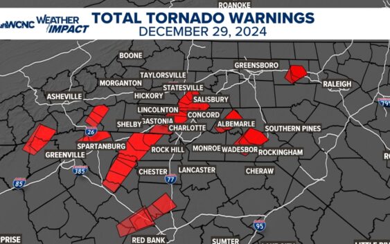
NWS doesn't find evidence of tornado in Gaston, Iredell counties

NWS stopped in Clinton, South Carolina, Union, South Carolina, Clover, South Carolina, Gastonia/Belmont, North Carolina, before ending in Cornelius and Mooresville.
CHARLOTTE, N.C. — The National Weather Service went out to survey the areas most impacted by the severe weather on Sunday.
It was moving so fast, that the worst of the weather only lasted for a few minutes, but that is all that it took to cause dozens of damage reports across the area. The National Weather Service already confirmed tornadoes north of Columbia, but it still needed to investigate the damaged areas closer to Charlotte.
NWS first stopped in Clinton, South Carolina, and made its way to Union, South Carolina. The organization also went to Clover, South Carolina, and north to Gastonia/Belmont, North Carolina, before ending up in Cornelius and Mooresville.
Despite multiple reports of strong winds that caused widespread damage and killed one person, NWS did not find any tornado damage in South Carolina or in Gaston or Iredell counties. The strong line of thunderstorms, however, was a textbook example of a well-known weather phenomena: A Quasi-Linear Convective System (QLCS).
These QLSCs move fast, sometimes moving at 45 to 60 mph.
This is because the winds within the storms are driving it faster. Any QLCS can produce damaging winds, large hail, dangerous lightning, heavy rain and even tornadoes. Most of the tornadoes that happen in North Carolina (especially the western Carolinas) occur along a QLCS.
This line was moving so fast that most of these warnings were replaced by new warnings from York up through Rowan County. Sadly, one person died near the Iredell-Rowan county line when a tree fell on their truck.
This event was special because it had the perfect set up of moisture and wind shear, maximizing its wind energy potential. The only thing that helped slightly was the time of day. If this occurred in the middle of the afternoon, the wind damage could have been even more widespread.