Dangerous travel conditions, ice/snow and flooding possible in the mountains Tuesday and Wednesday
WCNC Weather Impact Team is encouraging folks in the mountains to stay weather aware Tuesday and Wednesday due to the impacts from wintry precipitation.
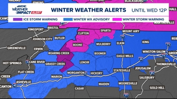
CHARLOTTE, N.C. — There is now an Ice Storm Warning, Winter Weather Advisory and Winter Storm Warning active for our North Carolina mountains. A wintry, damp and dreary pattern will be active through Thursday this week across the Carolinas.
When
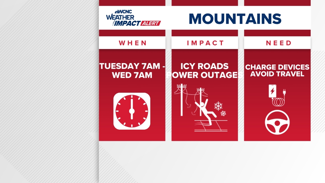
MOUNTAINS: As of 6 a.m. on Tuesday, North Carolina’s Department of Transportation (NCDOT) reported Watauga County had snow/ice covered primary and secondary roads. There will be a chance for snow, sleet and freezing rain on and off through Tuesday morning, but the heaviest accumulating ice will be from 3 p.m. until around midnight.
Some drier air will begin limiting wintry mix accumulations through the early morning hours. Even once precipitation stops, treacherous driving conditions will remain through the day on Wednesday.

The Ice Storm Warning ends at 7 a.m. Wednesday, Winter Weather Advisory ends at 7 a.m. and the Winter Storm Warning ends at 4 p.m..
CHARLOTTE: Off-and-on cold rain that will pick up Tuesday afternoon, continue through Tuesday evening and into Wednesday. The heaviest of this rainfall will begin Tuesday between 6 to 10 p.m. and last until midday Wednesday. Another round of rain will move in later Wednesday afternoon and will become widespread again through the evening and into the early morning hours Thursday. There is even a chance for thunderstorms (which would bring the heaviest rain potential) Wednesday into Thursday.
Impact

Winter impacts
The North Carolina mountains, the impacts will be the most significant. Heavy rain will certainly lead to flooding risks, but these communities will first have the rain fall as either sleet, snow and sleet and even all freezing rain (accumulating ice). This will be especially Tuesday morning through Tuesday evening, before the changeover to all cold rain.
This will create dangerous travel conditions for the mountains, while ice accumulations up to 0.25″ could lead to isolated power outages and downed trees. This is why our team has issued a Weather Impact Alert for Ashe, Watauga, and Avery counties on Tuesday and Wednesday, and we’re encouraging folks to stay weather aware. Areas in the Winter Storm Warning could have ice and sleet totals spread to over 4-8 inches.
Everyone will have the threat for flooding but it is highest for Western North Carolina.
Rainfall accumulations could quickly add up to 3-5 inches across the mountains, with 2-3 inches across the Charlotte metro. Although the most impactful days are Tuesday and Wednesday, scattered rain will linger into Thursday.
Ways to stay safe
- Keep updated with the forecast and stay off the roads if possible
- Avoid driving and/or traveling to the mountains
- Avoid low lying areas
- Check GPS ahead of time to see if there are any road closures that could block your commute
Contact Bekah Birdsall at rbirdsall@wcnc.com and follow her on Facebook, X and Instagram.
Contact Chris Mulcahy at cmulcahy@wcnc.com and follow him on Facebook, X, Instagram and TikTok.
Contact Brad Panovich at bpanovich@wcnc.com or follow him on Facebook, X and Instagram.
Contact Larry Sprinkle at lsprinkle@wcnc.com and follow him on Facebook, X and Instagram.
Contact Brittany Van Voorhees at bvanvoorhe@wcnc.com and follow her on Facebook, X and Instagram.
 If you like weather, watch Brad Panovich and the WCNC Weather Impact Team on their Emmy Award-winning Weather IQ YouTube channel.