- Triangle-area residents still reeling from storm damage brace for another round
- Severe weather storms forecast throughout South, Midwest; at least 3 dead in Texas
- Weather Impact Alert: Brad Panovich updates severe weather risk on Sunday
- Big March storm system threatens US with tornadoes, blizzards and wildfire risk
- As city leaders consider expanding at-risk zone for wildfire damage, home builders say it could raise costs
Weather Impact Alert: Dangerous travel conditions, ice/snow and flooding possible in the mountains Tuesday and Wednesday
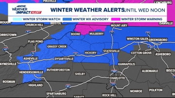
WCNC Weather Impact Team is encouraging folks in the mountains to stay weather aware Tuesday and Wednesday due to the impacts from wintry precipitation.
CHARLOTTE, N.C. — The damp and dreary pattern is now active through Thursday this week across the Carolinas.
When
The Charlotte area will experience off-and-on cold rain that will pick up Tuesday afternoon, continue through Tuesday evening and into Wednesday. The heaviest of this rainfall will begin Tuesday between 6 to 10 p.m. and last until midday Wednesday. Another round of rain will move in later Wednesday afternoon and will become widespread again through the evening and into the early morning hours Thursday. There is even a chance for thunderstorms (which would bring the heaviest rain potential) Wednesday into Thursday.
Impact
This means the biggest impact on the Charlotte area is the nuisance of this rain, which will be heavy at times, and isolated flooding.
However, for the North Carolina mountains, the impacts will be more significant. Heavy rain will certainly lead to flooding risks, but these communities will mix in snow, sleet and freezing rain, too. This will be especially Tuesday morning through Tuesday evening, before the changeover to cold rain.

This will create dangerous travel conditions for the mountains, while ice accumulations up to 0.25″ could lead to isolated power outages and downed trees. This is why our team has issued a Weather Impact Alert for Ashe, Watauga, and Avery counties on Tuesday and Wednesday, and we’re encouraging folks to stay weather aware.
Rainfall accumulations could quickly add up to 3-5 inches across the mountains, with 2-3 inches across the Charlotte metro. Although the most impactful days are Tuesday and Wednesday, scattered rain will linger into Thursday.


Ways to stay safe
Keep updated with the forecast and stay off the roads if possible
Contact Bekah Birdsall at rbirdsall@wcnc.com and follow her on Facebook, X and Instagram.
Contact Chris Mulcahy at cmulcahy@wcnc.com and follow him on Facebook, X, Instagram and TikTok.
Contact Brad Panovich at bpanovich@wcnc.com or follow him on Facebook, X and Instagram.
Contact Larry Sprinkle at lsprinkle@wcnc.com and follow him on Facebook, X and Instagram.
Contact Brittany Van Voorhees at bvanvoorhe@wcnc.com and follow her on Facebook, X and Instagram.