- Watering trees is a must to protect them from severe weather and drought
- At least 4 dead, hundreds rescued after deadly floods ravage South Texas
- Today on Texas Standard: Deadly floods swamp South Texas, shatter records
- North Carolina radio station was a critical lifeline after Hurricane Helene. Then it became the voice of recovery.
- As storms approach, Rock Hill residents look back on last April's devastating hailstorm
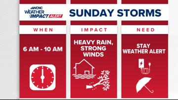
Weather Impact Alert: Severe weather threat on Sunday
A line of storms will bring the threat of severe weather to Charlotte on Sunday morning. Here are the potential impacts.
CHARLOTTE, N.C. — A line of storms could bring heavy rain, flooding and damaging winds to the Charlotte area and western North Carolina on Sunday morning.
The WCNC Weather Impact Team is declaring a Weather Impact Alert due to the threat of severe weather. Everyone in the Carolinas should be weather aware on Sunday morning, especially folks who will be traveling.
When
Storms will move into the mountains early Sunday, around 6 a.m. The leading edge of storms will be capable of producing heavy downpours and gusty winds. There will be a threat of storms from 6 a.m. until 10 a.m. from the mountains to the Charlotte metro area.
“This is going to be a pretty quick-moving system,” Weather Impact meteorologist Bekah Birdsall said.
As the storms push east, there will be a greater risk of severe weather in southern counties, where temperatures will likely be in the 60s as the system moves out of Charlotte.
Impact
Severe weather threat
Expect heavy rain and thunderstorms across the Carolinas on Sunday morning. These will be fast-moving storms. Wind gusts from 25-40 mph are possible, as well as the potential for severe weather. Those impacts could include localized flooding or even an isolated tornado. A flood watch is in effect for the mountains until 7 p.m. Sunday due to the torrential rain this week.
“We’re going to stay windy throughout the day on Sunday as that cold front makes its way through,” Birdsall said.

Even if Charlotte doesn’t see severe weather, there could be widespread power outages due to downed trees. Oversaturated soil from a rainy week could lead to a major problem, especially in south Charlotte where trees are more susceptible to falling during storms. City arborist Laurie Reid told WCNC Charlotte that homeowners should be prepared for the possibility of a tree falling in their neighborhood.
There’s also a chance of a wintry mix in the metro by the middle of next week.
Mountain snow
The mountains can expect wintry weather on the back end of Sunday’s system with snow flurries and showers possible late Sunday into Monday morning.