- Tuesday's wildfires scorched more than 500 acres in south Bexar County
- How big were this week's wildfires in Bexar County?
- Crews contain wildfire in southeast Williamson County
- Wildfire contained to 300 acres in northwest Matagorda County
- Bill would make it easier for homeowners to afford upgrades to protect from storm damage
Possible EF-1 tornado touched down in Union County, National Weather Service says
Preliminary data from the National Weather Service indicates the tornado was on the ground for about three minutes Wednesday morning.
INDIAN TRAIL, N.C. — A preliminary investigation by the National Weather Service indicates an EF-1 tornado with 90 mph winds touched down in Union County during Wednesday morning’s severe weather.
A spokesperson for the NWS said the possible tornado touched down at approximately 8:34 a.m. It was on the ground for about three minutes before lifting to the sky. The storm caused damage to several structures in the area of Friendly Baptist Church and Ridge Road, Union County officials said.
Union County Emergency Management Director Andrew Ansley confirmed no one was injured during Wednesday’s storm.
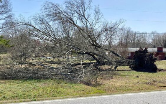
The storms passed through the Unionville and Indian Trail area around 8:30 a.m., taking down trees and power lines near Porter Ridge High School. Ansley said storm damage assessment crews spotted several downed power lines along Lawyers Road. WCNC Charlotte’s Austin Walker was in the area after the storm, where power crews were on the scene working to repair the broken poles.
Photos shared with Chief Meteorologist Brad Panovich show downed trees and small buildings that experienced damage.
WCNC Charlotte’s Austin Walker was on the scene along Lawyers Road and Highway 106 where the storm snapped power poles.
Panovich shared the photos with the National Weather Service, who said they would travel to the area later Wednesday to investigate the storm damage. The agency is scheduled to give an update at 3:30 p.m. Wednesday.
The locations of the photos help show the path of the storm. Damage reports sent to WCNC Charlotte show a northeast path from US 74 east along roads including Unionville-Indian Trail Road West, North Rocky River Road, Popline Road, Lawyers Road and Highway 601.
Liz Cooper with Union County Emergency Management said the agency hasn’t yet confirmed any specific damage at schools. Cooper shared that information during an interview on WCNC+, and also addressed concerns from parents worried about kids on buses during severe weather. Some districts, including Charlotte-Mecklenburg Schools, canceled class on Wednesday due to the storm threat.
“I can’t speak on behalf of Union County Public Schools,” Cooper said. “I think it’s normal for parents to be concerned anytime there is severe weather or they feel that their child’s safety may be in danger, but it’s a good reminder to trust the professionals who they are in trusted care with every day. I know that schools train for these types of events and I’m a parent of a Union County Public Schools student.”
Around 8:30 a.m., the same National Weather Service meteorologists had issued a tornado warning for Union County. At the time, a severe thunderstorm was moving through the area and was capable of producing a tornado.
The storm investigators will examine the damage Wednesday to determine if a tornado touched down, and if so, how strong the tornado was. If the damage is found to be inconsistent with tornado damage, National Weather Service storm investigators will still work to determine the strength of the thunderstorm winds that caused the damage.
Based on the damage they have seen, the WCNC Weather Impact Team preliminary believes the winds could have been at least 90 mph at the time of the storm.
The line of storms that produced the damage are moving east across the entire Carolinas. Before sunrise, the storms pushed into North Carolina and South Carolina. The storms are strengthening as they head east toward the coast.
Immediately after the storms cleared the area Wednesday morning, it was the Union County area that was reporting any of the most significant storm damage around the greater Charlotte area.