- McDowell County wildfire spreads to 500 acres, evacuation orders in place
- Evacuations in Caldwell County due to wildfire
- Northwest Houston 'ghost neighborhood' caused by repeated flooding to become latest detention basin
- NHL playoffs: Hurricanes open playoffs Easter Sunday afternoon vs. Devils
- 2 wildfires spreading in rugged terrain in western North Carolina
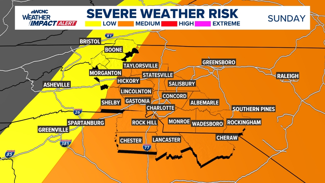
Weather Impact Alert: Brad Panovich updates severe weather risk on Sunday
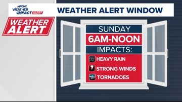
A risk of damaging winds and isolated tornadoes means you should stay alert for severe storms early Sunday.
CHARLOTTE, N.C. — The WCNC Weather Impact Team is tracking a severe weather system that’s expected to impact the Charlotte area early Sunday with the threat of heavy rain, damaging winds and isolated tornadoes.
Chief Meteorologist Brad Panovich is asking everyone in the Charlotte area to be weather aware because of the severe weather risks. This storm system is expected to have a greater impact across the Midwest before moving into the Carolinas early Sunday.
This storm system will be similar to the March 5 severe weather outbreak, which saw fast-moving storms and a tornado in the Charlotte area.
When

The severe weather threat is forecast between 6 a.m. and noon Sunday. Panovich says the greatest risk of tornadoes across the Charlotte area will likely be from around 6 a.m. until midday.
“To me, right now, the Piedmont 6-8 a.m. it starts to move across,” Panovich said. “Will there be embedded tornadoes? It’s hard to say, but right now it looks like a squall line, which is going to be an indication of more straight-line winds.”
Areas west of Charlotte, including the mountains and foothills, will catch the leading edge of storms between 3-6 a.m. Sunday. Those storms will then move into the Charlotte metro before pushing east of the Queen City toward areas like Rockingham and Wadesboro by around noon.
The severe weather should arrive after Charlotte FC’s home game on Saturday night, according to Panovich. Fans are advised to expect gusty winds and warming temperatures throughout the course of the match, though.
“I keep getting a lot of questions about the Charlotte FC game. I’m not concerned about it right now for severe weather, even rain, though I can’t rule out a stray shower,” Panovich said. “This is all coming in mostly after midnight Saturday into Sunday morning.”
Impact

The impact of this severe weather is heavy rain, damaging winds and tornadoes. There’s a low risk for hail and flooding, according to Panovich.
“Risk for tornadoes in the morning, 6-7 to about 11, but that’s where the biggest wind threat is,” Panovich said. “These things will fluctuate up or down, depending on how things unfold.”
Meteorologist Chris Mulcahy said Sunday’s storms could dump heavy rain on the region with up to 2 inches possible on top of the wind and tornado threats.
Need
In order to receive timely severe weather alerts, be sure to have multiple ways to receive weather alerts. One of those ways can be the WCNC Charlotte mobile app. Since the storms could arrive during the early morning hours, be sure to have a weather radio or other tool to awaken you in the event of a nearby storm.
Panovich says everyone should have three ways to receive real-time severe weather alerts. These include wireless emergency alerts that are built into most smartphones, weather apps and a NOAA weather radio that’s set to alarm during a tornado warning or other emergency.