- McDowell County wildfire spreads to 500 acres, evacuation orders in place
- Evacuations in Caldwell County due to wildfire
- Northwest Houston 'ghost neighborhood' caused by repeated flooding to become latest detention basin
- NHL playoffs: Hurricanes open playoffs Easter Sunday afternoon vs. Devils
- 2 wildfires spreading in rugged terrain in western North Carolina
Weather Impact Alert: Tornado watch issued for multiple counties
A tornado watch is in effect for Anson, Chesterfield, Stanly and Richmond counties in the Charlotte area until 2 p.. Sunday.
CHARLOTTE, N.C. — The WCNC Weather Impact Team is tracking a severe weather system pushing into the Charlotte area early Sunday morning with the threat of heavy rain, damaging winds and isolated tornadoes.
As of 6:25 a.m., Chief Meteorologist Brad Panovich said the risk of severe weather is decreasing for areas west of Interstate 77; however, the threat is increasing for areas east of Charlotte.
“West of I-77, the severe threat is lessening,” Panovich said. “Just gusty, non-thunderstorm winds. East of I-77, we’re watching the risk increasing with a new tornado watch until 2 p.m.”
A tornado watch is in effect until 2 p.m. for Anson, Chesterfield, Richmond and Stanly counties in North Carolina and South Carolina.
This storm system is responsible for at least 32 deaths and numerous tornadoes across the U.S. Deaths have been reported in several states, including Mississippi, Missouri and Arkansas. Several governors issued states of emergency due to the catastrophic damage caused by tornadoes in the Deep South.
When
The main threat of severe weather in Charlotte is between 5 a.m. and 9 a.m. Panovich said even without storms, Charlotte was already seeing high winds, with gusts up to 31 mph reported. Gusts up to 52 mph were recorded in the mountains, while most of the Charlotte metro saw gusts ranging from 25-32 mph.
“Will there be embedded tornadoes? It’s hard to say, but right now it looks like a squall line, which is going to be an indication of more straight-line winds,” according to Panovich.
Panovich anticipated a tornado watch for the area. The National Weather Service verified those concerns by issuing a tornado watch for Anson, Chesterfield, Richmond and Stanly counties until 2 p.m.
“There’s an 80% chance we could see a tornado watch for that area, and it could include parts of the Charlotte metro area,” Panovich said.
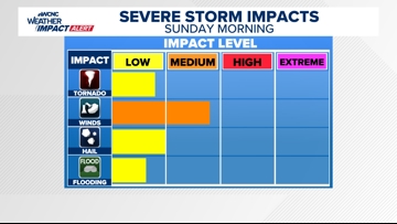
Impact

The impact of this severe weather is heavy rain, damaging winds and tornadoes. There’s a low risk for hail and flooding, according to Panovich.
Need
In order to receive timely severe weather alerts, be sure to have multiple ways to receive weather alerts. One of those ways can be the WCNC Charlotte mobile app. Since the storms could arrive during the early morning hours, be sure to have a weather radio or other tool to awaken you in the event of a nearby storm.
Panovich says everyone should have three ways to receive real-time severe weather alerts. These include wireless emergency alerts that are built into most smartphones, weather apps and a NOAA weather radio that’s set to alarm during a tornado warning or other emergency.