- Fake job seekers are flooding the market, thanks to AI
- One set of evacuation orders lifted in Caldwell County after wildfire contained
- 'We gutted every building' | Chimney Rock rebuilding after Hurricane Helene
- 'We gutted every building' | Chimney Rock rebuilding after Hurricane Helene
- Debris from Hurricane Helene provides fuel, complicates containment for spring wildfires
Evacuations in effect for parts of Montgomery, San Jacinto counties due to 2,000-acre wildfire | Schools close, shelters open
The fire quickly spread with high wind and low humidity.
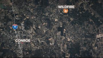
SAN JACINTO COUNTY, Texas — An estimated 2,000 acres are burning in a wildfire in San Jacinto County near the Montgomery County line, prompting evacuations and a school district to close. High wind and low humidity provided the fuel the fire needed to quickly spread.
According to an update from Texas A&M Forest Service at a little after 11 p.m. Wednesday, the fire — which has been named the Pauline Road fire — has grown to 2,000 acres between Conroe and Cleveland. The fire remains only 10% contained.
Evacuations
Around 900 homes are affected by evacuations, according to Montgomery County officials.
- At around midnight, The Montgomery County OEM issued new mandatory evacuations for people in the following locations: Holstein Dr., Hereford Way, Cross Cut, Rock Pigeon, Boar’s Run, Grey Goose, Brown Bear, Duroc Ct., Big Beaver, Blue Teal, Grant Lake Circle, N. Duck Creek north of Blue Teal
- As of 8:15 p.m., there were mandatory evacuations in place for the following roads in San Jacinto County: Pauline Road, Lee Turner Road, Kirby Road, Big Buck Road, Hereford Way and Blue Teal Road in San Jacinto County.
Montgomery County officials were telling residents south and west of Peach Creek that they need to be prepared to evacuate if the fire crosses the creek. There are voluntary evacuations for residents in the Doru Drive and Big Buck Drive areas.

Shelters
Cleveland ISD closed
Cleveland ISD posted a message late Wednesday night, saying that due to the ongoing Pauline Road fires and expected conditions, that the district will be closed on Thursday, March 20.
Livestock evacuated
Livestock is being evacuated from areas impacted by the fire. Residents are being told that if they need a safe place for animals, they can take them to Caney Creek Cowboy Church. It’s at 17703 Nonesuch Road in Conroe.
Fighting the fire
At this point, we don’t know how the fire started, but there is a continuing fire danger because of the high winds and low humidity.
Multiple agencies are on the scene battling the fire from the air and trying to contain it on the ground.
“Air operations will be dropping water. They’ll be taking water from overhead and dropping water,” Millsaps said. “The other way to fight fire in this case is to get a line around it. So that’s what the dozers are for. They’ll be going around and drawing protection lines around this to try to contain this fire. And so those are the two options that we’re using at this time. The firefighters on the ground are basically here to ensure those structures are not damaged in this process, and they are protecting those structures if fire encroaches on them, they’ll protect those structures.”
Earlier in the day, winds were gusting between 22 and 25 miles per hour from the northwest, according to KHOU 11 meteorologist Kim Castro. That was pushing smoke toward Cleveland and Liberty County. Drivers on Highway 69 should expect reduced visibility from the smoky haze.
Millsaps expects crews to be on the scene for quite a while.
“We’re going to continue to be battling this blaze well into the night with the winds,” Millsaps said. “However, the relative humidity is expected to rise every hour through the evening. That will assist us as the fire behavior will start to diminish and we’ll be able to get a better handle on it.”
According to the San Jacinto County Office of Emergency Management, a controlled burn was being performed by a landowner. They said it was supposed to be a 60-acre fire. It’s unclear if that’s the fire that sparked the wildfire.
The fire was so strong that the heat signal was picked up on radar and satellite imagery.
This is a breaking story. As soon as we have more information, we’ll post it here. You can also download the KHOU 11 app for updates as we get them.