- Fake job seekers are flooding the market, thanks to AI
- One set of evacuation orders lifted in Caldwell County after wildfire contained
- 'We gutted every building' | Chimney Rock rebuilding after Hurricane Helene
- 'We gutted every building' | Chimney Rock rebuilding after Hurricane Helene
- Debris from Hurricane Helene provides fuel, complicates containment for spring wildfires
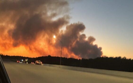
Wildfire in San Jacinto Co. grows to 1,300 acres, 10% contained | Several evacuations in place
According to Montgomery Co. OEM, people living off Lee Turner Road or any attached roads should evacuate immediately.
SAN JACINTO COUNTY, Texas — More than a thousand acres are burning in a wildfire in San Jacinto County near the Montgomery County line. High wind and low humidity provided the fuel the fire needed to quickly spread.
According to Texas A&M Forest Service, the fire — which has been named the Pauline Road fire — has grown to 1,300 acres to the north-northwest of FM 1725 near Alsobrooks Road. That’s between Conroe and Cleveland. The fire is 10% contained.
There are no injuries reported and so far, no structures have been affected, but according to Jason Millsaps with Montgomery County Judge Mark Keough’s Office, several homes were evacuated and a shelter was being opened in Coldspring.
As of 8:15 p.m., there were evacuations in pace for the following roads: Pauline Road, Lee Turner Road, Kirby Road, Big Buck Road, Hereford Way and Blue Teal Road.
At this point, we don’t know how the fire started, but there is a continuing fire danger because of the high winds and low humidity.
Multiple agencies are on the scene battling the fire from the air and trying to contain it on the ground.
“Air operations will be dropping water. They’ll be taking water from overhead and dropping water,” Millsaps said. “The other way to fight fire in this case is to get a line around it. So that’s what the dozers are for. They’ll be going around and drawing protection lines around this to try to contain this fire. And so those are the two options that we’re using at this time. The firefighters on the ground are basically here to ensure those structures are damaged in this process, and they are protecting those structures if fire encroaches on them, they’ll protect those structures.”
Earlier in the day, winds were gusting between 22 and 25 miles per hour from the northwest, according to KHOU 11 meteorologist Kim Castro. That was pushing smoke toward Cleveland and Liberty County. Drivers on Highway 69 should expect reduced visibility from the smoky haze.
Millsaps expects crews to be on the scene for quite a while.
“We’re going to continue to be battling this blaze well into the night with the winds,” Millsaps said. “However, the relative humidity is expected to rise every hour through the evening. That will assist us as the fire behavior will start to diminish and we’ll be able to get a better handle on it.”
According to the San Jacinto County Office of Emergency Management, a controlled burn was being performed by a landowner. They said it was supposed to be a 60-acre fire. It’s unclear if that’s the fire that sparked the wildfire.
The fire was so strong that the heat signal was picked up on radar and satellite imagery.
This is a breaking story. As soon as we have more information, we’ll post it here. You can also download the KHOU 11 app for updates as we get them.