NC's largest wildfire has spread to a second county
Polk County Emergency Management on Friday afternoon issued a mandatory evacuation for all residents of the Piney Gate area.
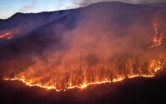
CHARLOTTE, N.C. — Three massive wildfires continue to burn thousands of acres in western North Carolina. With over 5,000 acres burned, two of the biggest fires remain uncontained.
As of Tuesday, the Black Cove Fire had burned an estimated 3,046 acres and was 0% contained. The Deep Woods Fire is approximately 2,923 acres and also 0% contained. The Fish Hook Fire is 199 acres and 69% contained. Polk County officials said there are 249 personnel from across North Carolina and other states working to extinguish the fires.
In total, 165 homes in Polk County are under mandatory evacuation. Between two and four homes have been destroyed by the fire.
On Tuesday, officials published a new map showing the evacuation zone. Residents in green are being told for possible evacuations while residents in yellow are being told an evacuation is immininent. Residents in red are to evacuate immediately.
On Tuesday, Satellite data showed smoke and flames crossing from Polk County into Henderson County along the Green River.
Dry weather conditions with gusty winds have allowed the fires to spread. Officials are now watching for the state’s largest fire, the Black Cove fire, to possibly spread into neighboring Henderson County.
Black Cove Fire
The Black Cove Fire was first reported on Wednesday, March 16. It was mapped at 3,046 acres in size and is 0% contained. Polk County officials said the fire began on state-owned and private land in the Green River Gorge, about two miles northeast of Saluda. Firefighters are building control lines on both sides of the river to prevent the flames from reaching residential areas west of the fire. The fire was moving toward Henderson County.
Evacuation orders were issued for residents in the following areas:
- Green River Cove Road addresses from 1091 to 1528
- Lady Slipper Trail
- Big Hungry Road
- Spurgeon Cove Lane
- English Heifer Cove Road
- Deer Trail
- Scarlets Mountain Road
“We are a little nervous for the top side of the Black Cove fire because that is starting to creep into Henderson,” Polk County Public Information Officer Kellie Cannon said Monday of their neighboring county.
Deep Woods Fire
The Deep Woods Fire was reported on March 19 and has grown to 2,923 acres. It’s also 0% contained. The fire is burning state- and private-owned land in the Green River Gorge and in the Holbert Cove community, about five miles northwest of Columbus. Firefighters are working to provide building protection on the south side of the fire to prevent it from spreading along Holbert Cove Road.
Evacuation orders are in place for residents in the following areas:
- Holbert Cove Road from addresses 5079 to 7265
- Fox Paw Lane
Fish Hook Fire
The Fish Hook Fire was first reported on Thursday, March 20. It’s grown to about 200 acres and is approximately 69% contained. Polk County officials said the fire hasn’t grown but the acreage estimates have changed with more accurate mapping on Sunday. It’s burning on private land near Lake Adger, about five miles northwest of Mill Spring. All evacuations related to the Fish Hook Fire have been lifted and containment is expected to increase in coming days as crews work to extinguish smoldering fuels on the fire’s edge.
Polk County Emergency Management on Friday afternoon issued a mandatory evacuation for all residents of the Piney Gate area. An updated order shared later Saturday afternoon called for neighbors along Green River Cove to evacuate. The county also ordered evacuations for 5079-7265 Holberts Cove Road on North Side and Fox Paw Lane.
“Visibility in the area will be reduced and roads/evacuation routes can become blocked; if you do not leave now, you could be trapped, injured or killed,” the agency warned.
Evacuation shelter
In Polk County, an evacuation shelter is being run by the American Red Cross at 75 Carmel Lane in the city of Columbus.
Firefighting efforts
Crews are attacking the flames from both the ground and the air but are running into unique challenges.
“Access has been our number one concern. We are fighting in rugged and remote terrain, some of the most rugged you’d see in western North Carolina,” E.J. Dwigans of the North Carolina Forest Service said. “Access into these areas is limited as well. We have crews on the ground, we have hand tools, backpack leaf blowers to clear debris around structures.”
Dwigans said crews are flying aircraft whenever possible but cannot fly if the winds become too strong.
Statewide fire ban
The North Carolina Forest Service has issued a statewide ban on all open burning effective 8 a.m. Friday, March 21, due to escalating wildfire risks caused by dry conditions.
“It is spring wildfire season in North Carolina, and we are seeing wildfire activity increase due to dry conditions,” Agriculture Commissioner Steve Troxler said in a statement Thursday. “With these ongoing conditions, a statewide burn ban is necessary to reduce the risk of wildfires starting and spreading quickly.”
The prohibition applies to all 100 counties and cancels all existing burning permits. Officials have also suspended the issuance of new permits until the ban is lifted. Under North Carolina law, violators face a $100 fine plus $183 in court costs. Additionally, individuals responsible for setting fires may be held liable for expenses related to extinguishing them.
The ban includes an exception for fires started within 100 feet of an occupied dwelling, where local fire marshals retain authority to issue restrictions.
“Our top priority is always to protect lives, property and forestland across the state,” Troxler added. “It is imperative that folks adhere to this burn ban until further notice.”
Local fire departments and law enforcement officers will assist the N.C. Forest Service in enforcing the restrictions.
Officials say the Forest Service will continue monitoring conditions. Residents with questions about specific counties should contact their county ranger or fire marshal’s office.