- Wildfire in New Jersey Pine Barrens expected to grow before it’s contained, officials say
- Storm damage forces recovery efforts in Lancaster, Chester counties
- Evacuation orders lifted as fast-moving New Jersey wildfire burns
- Heartbreak for NC resident as wildfire reduces lifetime home to ashes
- ‘It’s only going to get worse’: Wildfire risk grows in western North Carolina
Carolina wildfires grow, evacuation orders still in effect

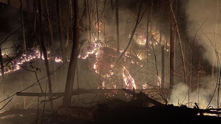
The Table Rock Complex has grown to over 10,000 acres as South Carolina crews battle the massive wildfires.
CHARLOTTE, N.C. — Wildfires in both North Carolina and South Carolina are continuing to spread with little containment.
The biggest fires are within 20 miles of each other. In North Carolina, the Black Cove, Deep Woods and Fish Hook fires are now being tracked under the consolidated umbrella of the Black Cove complex. The fires, which started in Polk County, have now spread into Henderson County. Over 300 firefighting personnel are battling the wildfire.
In South Carolina and part of North Carolina, the Table Rock wildfire and Persimmon Ridge fire are known as the Table Rock Complex. That fire has now grown to over 13,000 acres.
State of Emergency
North Carolina Gov. Josh Stein issued a State of Emergency for 30 counties to expand the response to these fires.
“The wildfires in western North Carolina continue to grow, so I have expanded our State of Emergency,” Stein said in a statement. “Our State Emergency Response Team is responding with every tool at its disposal. Please stay safe and stay alert for any evacuation orders if the fires spread to an area near you.”
The state of emergency was issued for the following counties: Alexander, Alleghany, Ashe, Avery, Buncombe, Burke, Cabarrus, Caldwell, Catawba, Cherokee, Clay, Cleveland, Gaston, Graham, Haywood, Henderson, Iredell, Jackson, Lincoln, Macon, Madison, McDowell, Mecklenburg, Mitchell, Polk, Rowan, Rutherford, Stanly, Swain, Transylvania, Union, Watauga, Wilkes and Yancey. It also includes the tribal lands held by the Eastern Band of Cherokee Indians.
In South Carolina, the Table Rock Fire Complex consists of the fire burning at Table Rock State Park in Pickens County and the Persimmon fire burning in Caesars Head in Greenville County.
Dry weather conditions with gusty winds have allowed the fires to spread. Combined, the fires have burned thousands of acres. With the exception of the Fish Hook fire, the wildfires have no containment and are continuing to spread.
Black Cove Fire Complex
North Carolina officials published a new map showing the evacuation zones in Polk and Henderson counties. Residents in green are being told of possible evacuations, while residents in yellow are being told an evacuation is imminent. Residents in red are to evacuate immediately.
Polk County evacuations
As of Thursday, evacuations have been issued for the following areas in Polk County:
- 3509-4523 Green River Cove Road
- Wilderness Cove Trail
- 3155 -6159 Holbert Cove Rd
- Cove Rd
- Coyote Ridge
- Sam’s Gap Ln
- Big Hungry Rd
- Deer Trl
- English Heifer Cove Rd
- Scarlets Mountain Rd
- Spurgeon Cove Ln
- 5079 – 7265 Holbert Cove Rd (North Side)
- Fox Paw Ln
- 1091 – 1528 Green River Cove Rd
- Lady Slipper Tr
- Charity Branch Dr
- Deep Woods Ln
- Gamelands Trl
- Moonshine Trc
- Oakview Ln
- Piney Gate Rd
- Piney Overlook Ln
- Wesley Ln
- Windsong Ln
- Volley Way
In Polk County, an evacuation shelter is being run by the American Red Cross at 75 Carmel Lane in the city of Columbus.
Henderson County evacuations
Officials issued an evacuation order for the Summer Haven community in Henderson County. This includes Macedonia Road east of Interstate 26, Skyland Acres Road, Knight Road, Summer Haven Lane and S. Fine Way.
In Henderson County, a shelter is open at the Henderson County Parks & Recreation Athletics and Activities Center at 708 South Grove Street in Hendersonville.
Black Cove Fire
The original Black Cove Fire was first reported on Wednesday, March 16. As of 7 p.m. on March 29, 2025, the Black Cove Complex remains the highest-priority fire in the country. It has thus far torched 3,500 acres and is 35% contained.
Polk County officials said the fire began on state-owned and private land in the Green River Gorge, about two miles northeast of Saluda. The fire was caused by a downed power line.
A firefighter was injured in this fire and airlifted to a nearby hospital, where he is in stable condition.
“As daytime operations draw to a close, firefighters conduct strategic firing operations through the night, taking advantage of higher humidity and lower temperatures. With low visibility and smoky conditions, nighttime firefighting can be a risk, but lower intensity fire behavior offers opportunities to increase containment during these critical hours of darkness,” the N.C. Forest Service said in a Saturday morning update.
Deep Woods Fire
The Deep Woods Fire was originally reported on March 19. As of 7 p.m. on March 29, the fire had grown to 3,970 acres and was 32% contained. The fire is burning state-owned and private land in the Green River Gorge and in the Holbert Cove community, about five miles northwest of Columbus.
Evacuation orders are in place for residents in the following areas:
- Holbert Cove Road from addresses 5079 to 7265
- Fox Paw Lane
Fish Hook Fire
The Fish Hook Fire was first reported on Thursday, March 20. It has maintained a size of about 200 acres and is now 100% contained. It burned on private land near Lake Adger, about five miles northwest of Mill Spring. All evacuations related to the Fish Hook Fire have been lifted.
Additional fires
Transylvania County
The Table Rock Fire complex is threatening parts of Transylvania County. The complex is burning at more than 13,000 acres total, mostly in South Carolina. As of the last public update on Thursday, the fires in Transylvania County are confined to state forests. The expansion of this fire is directly impacting the Connestee Fire and Cedar Mountain District.
A rapidly intensifying wildfire was first reported in North Carolina’s Transylvania County overnight Wednesday. Officials issued an evacuation for the Big Hill Community, Dolly Masters Road, Glady Fork Road, Lake Honda and Happy Acres Communities.
“There was little movement in the fireline overnight and no change to the evacuation zone,” the county said in a Saturday morning briefing.
East Fork Road is closed from the East Fork entrance of Connestee Falls to Glady Fork Road so crews can get through.
No homes have been impacted as of Saturday morning, the county said.
The Rattlesnake Branch Fire grew to just over 790 acres in Pisgah National Forest outside the county by Saturday afternoon.
Health officials warn residents to consider limiting prolonged or heavy exertion outdoors.
Swain County
The Alarka Five fire has burned approximately 970 acres and is 5% contained, according to state officials. Evacuations are in effect for Long Creek, Alarka Highlands and Unahala Creek.
Smaller scene in Catawba County
A new fire near the towns of Hickory and Conover in Catawba County broke out Friday afternoon. It was eventually contained.
Table Rock Fire Complex
The Table Rock Fire grew significantly between Thursday and Saturday, and now covers over 10,900 acres. The South Carolina Forestry Commission said Thursday night that no new evacuations were ordered, but gusty, dry conditions are expected on Friday, which could cause the fire to grow rapidly.
The fire is 9% contained as of March 30, at 8:30 a.m.
The Persimmon Ridge fire near Caesars Head is now 2,000 acres, officials said. The Persimmon Ridge fire is about 24% contained.
What caused the Table Rock Fire?
Pickens County Sheriff Tommy Blankenship posted a message on Facebook saying young men, described as hikers, were responsible for starting the fire. Blankenship said the hikers were “negligent” and that’s what led to the forest fire.
The hikers haven’t yet been identified and no charges have been announced, but Blankenship said that would come at a later date.
Pickens County evacuations (voluntary)
- Asia Li Ln
- Bird Song Trl
- Blue Mountain Way
- Bluff Ridge Rd
- Bobcat Dr
- Bridle Dr
- Caesars Head Hwy
- Cherry Blossom Ln
- Cisson Ridge Rd
- Cold Mountain View
- Cougar Trl
- Cripple Creek Rd
- Curts Way
- Dogwood Mountain Rd
- Dry Lake Rd
- Duckwood Ln
- Elizabeth Dr
- Fast Ln
- Fish Hawk Rd
- Green Acres Dr
- Hardin Rd
- Hardwood Ln
- Hwy 11
- Ledge Rd
- Locust Rdg
- Misty Mountain Way
- Mulligan Ford Hill Rd
- Pumpkin Ln
- Pumpkin Mountain Rd
- Raven Cliff Rd
- Raven Ct
- Ridge Springs Rd
- River Bluff Rd
- River Rd
- Rockcrest Rd
- Rockcrest Rdg
- Rockview Ct
- Rocky Rd
- S Saluda Rd
- Saluda Hill Rd
- Saluda Shore Dr
- Trinity Trl
- Wayside Dr
- Wild Brook Dr
- Winding Trl
- Wotawok Trl
Greenville County evacuations
- Table Rock Road
- Matthews Creek Lane
- River Rock Court
- Ragsdale Road
- Pipe Line Lane
- Gintomo Road
- Hagood Road
- Haygood Road
- Lakemont Road
- Caesars Head Highway
- Sky Ranche Road
- Asbury Drive
- Laurel Drive
- Saluda Hill Church Road
- Geer Highway
- Burgess Road
- Grey Logs Trail
- Caesars Point
- River Rock Court
- Spring Park Drive
- North Lake Drive
- Trails End
- Boy Scout Road
- Sevenbark Lane
- Larkspur Lane
- Table Rock Road extension
- Mountain Laurel Drive
- Birchbend
- Sourwood Lane
- Conifer Falls Road
- Hemlock Trail
- Cliff Ridge Drive
- Rhododendron
- Trillium Way
- Chestnut Blf
- Echo Drive
- Echo Drive extension
- Jack Ray Drive
- Southside Drive
- Sunrise Drive
- Upper Oil Camp
- Woodvine
- Columbine Way
- Old Springfield Road
- Rosemond Road
- Burgess Road
- Lookoff Drive
- Club Terrace Drive
- Wildcat Road
- Punctatum Pl
- Point Of View Lane
- Happy Acres Road
Firefighting efforts
Crews are attacking the flames from both the ground and the air but are running into unique challenges.
“Access has been our number one concern. We are fighting in rugged and remote terrain, some of the most rugged you’d see in western North Carolina,” E.J. Dwigans of the North Carolina Forest Service said. “Access into these areas is limited as well. We have crews on the ground, we have hand tools, backpack leaf blowers to clear debris around structures.”
Dwigans said crews are flying aircraft whenever possible but cannot fly if the winds become too strong.
Statewide fire ban
The North Carolina Forest Service has issued a statewide ban on all open burning effective 8 a.m. Friday, March 21, due to escalating wildfire risks caused by dry conditions.
“It is spring wildfire season in North Carolina, and we are seeing wildfire activity increase due to dry conditions,” Agriculture Commissioner Steve Troxler said in a statement Thursday. “With these ongoing conditions, a statewide burn ban is necessary to reduce the risk of wildfires starting and spreading quickly.”
The prohibition applies to all 100 counties and cancels all existing burning permits. Officials have also suspended the issuance of new permits until the ban is lifted. Under North Carolina law, violators face a $100 fine plus $183 in court costs. Additionally, individuals responsible for setting fires may be held liable for expenses related to extinguishing them.
The ban includes an exception for fires started within 100 feet of an occupied dwelling, where local fire marshals retain authority to issue restrictions.
“Our top priority is always to protect lives, property and forestland across the state,” Troxler added. “It is imperative that folks adhere to this burn ban until further notice.”
Local fire departments and law enforcement officers will assist the N.C. Forest Service in enforcing the restrictions.
Officials say the Forest Service will continue monitoring conditions. Residents with questions about specific counties should contact their county ranger or fire marshal’s office.