- NC's FEMA aid extension for Hurricane Helene recovery denied
- NC's FEMA aid extension for Hurricane Helene recovery denied
- NC Gov. Stein pledges continued Hurricane Helene recovery support in 100-day address
- Austin adopts new map that greatly expands area at risk of wildfire
- CenterPoint Energy accelerates infrastructure improvements ahead of hurricane season
Austin adopts new map that greatly expands area at risk of wildfire
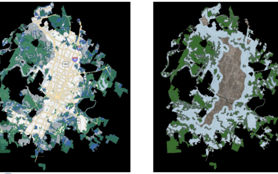
Businesses and homes that sit on just over half of all habitable land in the City of Austin are now at risk of being destroyed in a wildfire, according to a map City Council members adopted Thursday.
The map is included in changes to the city’s Wildland-Urban Interface, or WUI, which regulates areas where wilderness abuts development and homes and businesses are most likely to be wrecked by wildfire.
Historically, homes in West Austin have had the greatest risk of wildfire damage. New risk areas include much of South Austin and neighborhoods just west of downtown.
The latest map puts 51% of Austin’s habitable land — tens of thousands of acres — in a risk zone. That’s up from 38% nearly a decade ago. It’s not clear how many homes and businesses this affects.
Any homes or businesses built or renovated in these areas will need to be “hardened” against burning. That means builders and owners will have to use fire-resistant materials, install tempered glass and cover vents with metal screens.
City of Austin
Thursday’s vote comes amid growing concern over wildfires in Central Texas. Austin ranks fifth in the nation on a list of cities with the highest number of homes at risk of being damaged by fires.
In mid-March, a fire burned nearly 10,000 acres just north of Fredericksburg. Smoke traveled east to Austin, darkening city skies.
Austin’s new wildfire map delineates three risk zones. Buildings within Zones A and B have a higher chance of being destroyed in a wildfire. Buildings in Zone C are less likely to be damaged.
The map’s expansion is largely due to decisions by the fire department to put more of the city into Zone C. Fire officials cited studies showing how far embers from a fire can travel, igniting roofs or other parts of homes.
“Those embers that can go over a mile … can land in a gutter that has leaf litter in it, can land in a corner that has leaf litter built up or combustible mulch right up against a house that has combustible siding,” André de la Reza, an assistant chief with the Austin Fire Department, said.
Representatives from Austin’s building community had asked council members Thursday to postpone the vote. City staff said they estimate requiring the use of fire-resistant materials in a much larger part of the city will increase the cost of building.
But a 2018 study from a nonprofit research group, Headwaters Economics, found it is possible to build a fire-resistant home for the same cost of building a typical one.
Researchers looked at parts of homes that are vulnerable to fires, including roofs and exterior walls and found that it cost roughly $81,000 to build these parts of a typical home, and $79,000 when using fire-resistant materials.
Owners of existing properties will not be required to retrofit their homes, but Mayor Kirk Watson asked city staff to look into ways to encourage homeowners to make these changes.