- Seven months after Hurricane Helene, Chimney Rock rebuilds with resilience
- Wildfire in New Jersey Pine Barrens expected to grow before it’s contained, officials say
- Storm damage forces recovery efforts in Lancaster, Chester counties
- Evacuation orders lifted as fast-moving New Jersey wildfire burns
- Heartbreak for NC resident as wildfire reduces lifetime home to ashes
Was it a tropical storm that impacted the Carolinas?
Potential Tropical Cyclone 8 never officially became a tropical storm even though its impacts and wind speeds match the criteria. Here is the reason why.
WILMINGTON, N.C. — On September 16, a strong low-pressure system made landfall in the Carolinas. The storm had wind speeds sustained to 50 mph with gusts over 60 mph. Despite having winds strong enough for a tropical storm, this tropical weather system never received a name.
Instead this slow-moving system was named Potential Tropical Cyclone Number 8, or PTC 8, by the National Hurricane Center.
The NHC started issuing using these “potential tropical cyclone” titles back in 2017. The goal is to give communities warnings for tropical storm or hurricane-like conditions for a storm that hasn’t been officially named yet.
This storm would have become Tropical Storm Helene had only a few things been different.
Here is why it wasn’t named
With sustained winds at 50 mph, the weather system had tropical storm-force winds. So the real-world impacts were the same as any other tropical storm with gusty winds and even flooding and tornado warnings.
However, this storm had some organizational characteristics that disqualified it from proper classification
As it moved inland, it did not have a defined center of circulation. A tropical storm or hurricane will have its strongest winds at the center of circulation. This is most often referred to as the “eye of the storm.” PTC 8 had its strongest winds in the outer bands away from its center of circulation.
Also, there were a string of stationary fronts that was connected to the low-pressure system itself.
The lack of a proper center of circulation and the interaction with the fronts disqualified it from official classification, according to the rules used by meteorologists.
What’s in a name?
This proves that a name doesn’t define a storm. Even without a name, the impacts of this PTC are the same as if the storm system had received the name Helene. However, “Helene” never was.
With comparable impacts, the lesson is to take storm preparations just as seriously for a “potential tropical cyclone” as would be for a named tropical storm.
Digging deeper
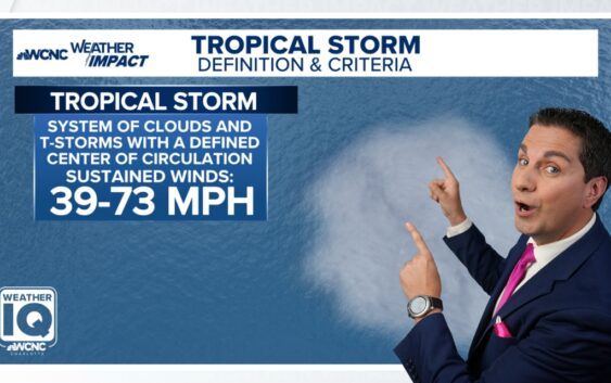
A tropical depression, tropical storm and hurricane are all technically called “tropical cyclones.” According to the National Weather Service, a tropical cyclone is:
“A warm-core non-frontal synoptic-scale cyclone, originating over tropical or subtropical waters, with organized deep convection and a closed surface wind circulation about a well-defined center.”
To simplify:
- The storm must not be attached to fronts
- Forms over subtropical or tropical waters
- Has a closed circle on a surface map showing a well defined center
Once these criteria are met, the peak sustained winds around the storms center will determine its classification:
- Winds up to 38 mph will be a tropical depression
- Winds between 39 and 73 mph will be a tropical storm
- And winds 74+ mph will be a hurricane. And will be broken down into categories using the Saffir-Simpson scale.