- 20-million-gallon detention basin in Meyerland designed to help prevent flooding
- Firefighters report significant progress on McDowell County wildfire
- How to watch the FireAid benefit concert for LA wildfire relief
- FireAid, a benefit for LA wildfire relief, is almost here. Here’s how to watch and donate
- Burgaw Mayor to speak with Western North Carolina officials about flooding
Weather Aware: Impacts of Hurricane Helene in the Carolinas
Scattered rain and storms this week have soaked some areas ahead of tropical moisture arriving tomorrow through Friday. Stay weather aware!
CHARLOTTE, N.C. — A cold front moving in from the northwest is bringing scattered rain and storms to the Charlotte area this afternoon and tonight. On top of this, the Carolinas are bracing for impacts from Tropical Storm Helene beginning tomorrow.
The tropical storm watch is in effect for Avery, Burke, Caldwell and Cleveland counties in North Carolina. A flood watch is in effect for Ashe, Avery, Burke, Caldwell, Catawba, Cleveland, Lincoln and Watauga counties until 8 p.m. on Thursday. Areas impacted by these watches and warnings include Boone, Gastonia, Hickory, Lenoir, Lincolnton, Morganton, Newland and Shelby.
When will the Carolinas see the impact?

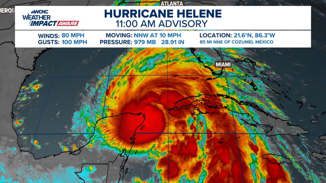
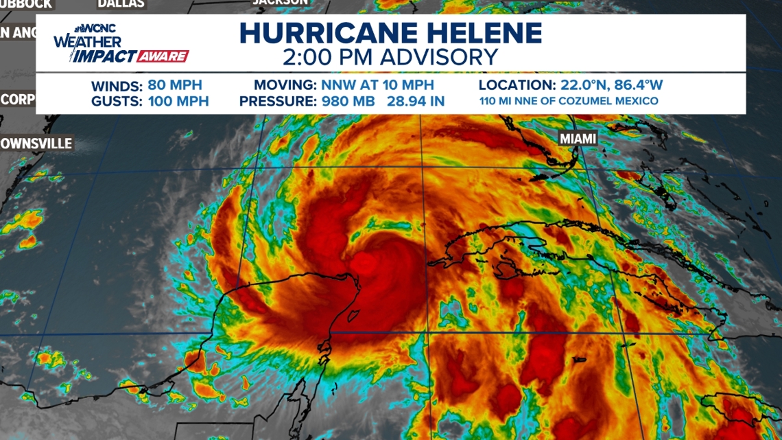
As of 2 p.m. Wednesday, Helene is moving into the southeastern Gulf of Mexico with 80 mph winds. The storm is located about 110 miles north-northeast of Cozumel, Mexico, and is moving north-northwest at 10 mph. Helene is expected to move into the extremely warm Gulf waters where it will experience rapid intensification.
The forecast cone for Helene remains largely unchanged from previous models. Once the storm system moves into the Gulf of Mexico on Wednesday, it is expected to rapidly become a hurricane. It could possibly make landfall in the Big Bend area of Florida Thursday night, and could at that point be considered a major hurricane.
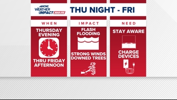
By 9 a.m. Friday morning, Helene’s forecast cone indicates it will pass through Georgia and western South Carolina and move into North Carolina and eastern Tennessee. The greater Charlotte area is forecast to see heavy rain early Friday morning through early afternoon.

Any rain in the next few days will soak the ground ahead of the tropical moisture.
What impacts to expect

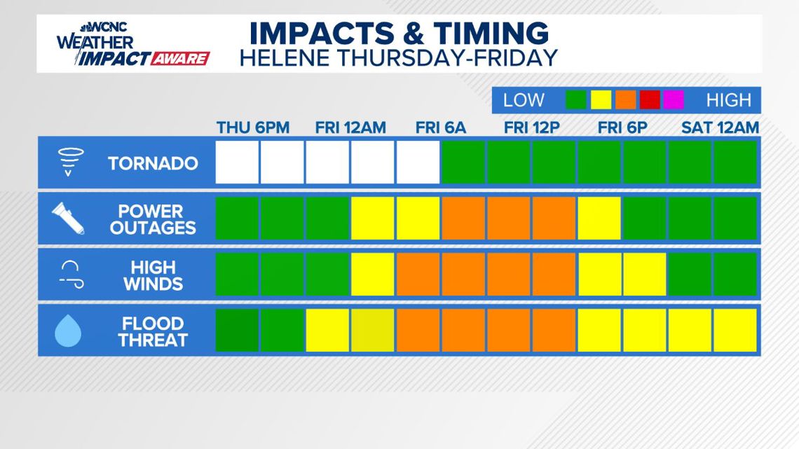
Expect rain totals up to 10 inches in the mountains and up to 5 inches in the Charlotte area, as well as a chance of tropical storm force winds on Friday. Panovich said this could lead to tree and power line issues on Friday.
Panovich said we should see better weather ahead for the weekend, as the wind and rain will move out fairly quickly.
What you need to know to stay safe
In the event of a severe storm, stay Weather Aware by:
- Seeking shelters indoors away from lightning and gusty winds
- Watching for flooded creeks and streams
- If you encounter a flooded roadway: turn around, don’t drown
- Monitoring radar for quick-moving thunderstorms that could disrupt outdoor plans
When temperatures get high in the Carolinas, it’s important to stay Weather Aware by:
- Limiting your time outside/take breaks
- Staying hydrated
- Seeking shade when available
- Checking on the elderly and pets